| |
| |
FR004 Water Hollow Rd s(u)
One of my favorite dirt roads in
Central Utah is Skyline Drive over the crest line
of the Wasatch Plateau. But it often takes till
the middle of summer till this road is completely
free of snow. This summit on the west side of the
crest, does not go as high, but it also passable
much earlier in the year. The center piece of the
landscape on this ride is Mary's Nipple - an
outstanding land mark of the southern Wasatch
Plateau.
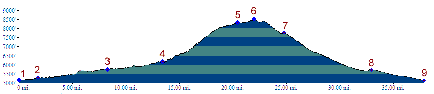
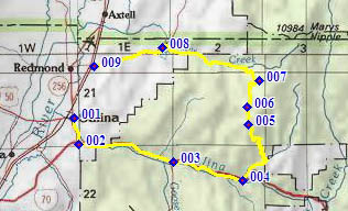
From South. The profile starts in the
center of Salina (or as they like to call it
"Salina City"), and gets onto I70 heading east.
Soon, what appears to be an unpaved service road
to I70 appears on the south side. But there is no
way to get to it, on the other side of a at least
10ft high fence. Periodically there are gaps in
the fence and you can access the side road by
lowering the bike down a 6 ft drop. But the
spacious shoulder of I70 is a faster ride anyway,
and the first exit is not far away. From the Gooseberry Road exit the profile follows
the service road, which has a few more ups and
downs, no washboard (Jun/13) and passes under I70.
The turnoff to FR004 is well signed. The road
starts to climb right away, and the slope is more
variable than the profile makes it appear. The
road has a good riding surface. After a good
climbing workout the route rolls along on a
traverse with great views onto the Sevier Valley.
The Great Western ATV trail joins the road from
the west, and then leaves the road at its summit,
direction east. The top is surrounded with trees
with views directly from here. 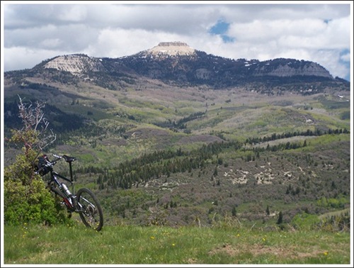
From North. (described downwards). But
immediately afterwards the first of several great
views of Mary's Nipple - the mountain, 10984ft -
you'll recognize it when you see it, no
description necessary. This peak makes an easily
recognizable landmark ranging from I70 over the Meadow Gulch
Divide to the Sevier Valley. The profile turns left onto FR001, coming down
from Skyline Drive at Willow Park. A fast descent
on a wide, but hard dirt packed road follows
Willow Creek down through the tilting layers of
sedimentary rocks. The far views disappear, but by
the time the road has passed Willow Creek
Reservoir, Mary's distinctive Nipple is in the
field of view again in the distance. Turn left
onto US89 to get back to Salina. Dayrides. PARTIALLY PAVED / UNPAVED (<Baxter Pass|Niotche -
Lost Creek Divide>)
back to cycling Utah's summits and passes |
||||||||||||||||||||||||||||||||||||||||||||||||||
 Approaches
|
|
advertisement |
|
|
advertisement |