| |
| |
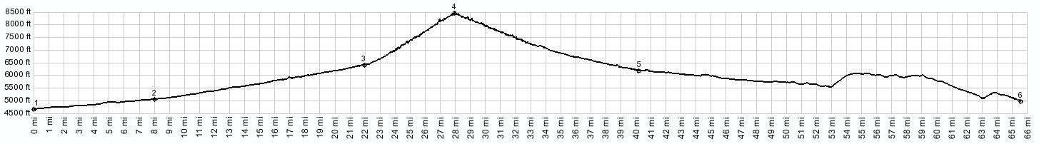
Baxter Pass
It's not often, that a pass is
named after an old asphalt company, or at least
one of its principals. Maybe you would expect,
that such a pass then is paved with the smoothest
of asphalts, worthy of some great bicycle race.
But this is not so. This is a rough dirt road
through a really lonesome, isolated corner of
Colorado. For more on the asphalt connection, see
the history notes below.
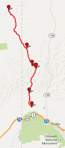
From South. It seems like good place to
start a ride over Baxter Pass would be the I70
Mack exit. You see a lot of bicycles at the exit -
mostly top of car roofs But they all head in the
other direction, into the McInnis Canyon
conservation area with its popular trails. The
ride towards Baxter Pass turns out to be quite
long when you start here. The route stays on
pavement for now and follows the edges of squares
along property boundaries, until it reaches a low
point, where it crosses West Salt Creek. This is
where the profile starts. There are several more
miles of pavement with a wonderful absence of
traffic, until the smoothness stops abruptly, at
the intersection with Prairie Canyon. You could
argue that this was the best part of the ride.
After a short distance the arguably worst part of
the ride, comes in the form of a wide gravel road
which leads as far as the South Canyon gas
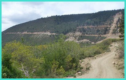
compressor station. Shortly afterwards the road enters the Book
Cliffs, now on a better bikable surface. As all
the Book Cliff approaches from the south, the road
has a few short sandy stretches in the lower part,
but nothing that would make you get off the bike.
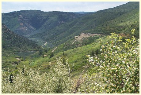
Very little changes about the canyon scenery
during the climb. It looks the same, even though
the road has been climbing. How can this be ? The
reason is that the valley bottom climbs at roughly
the same rate as the plateau top, maybe a little
faster. This too is very similar to other Book
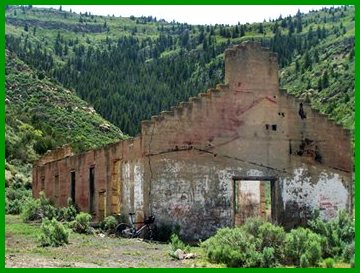
Cliff roads on the south side. Finally the rest of
an old concrete building, probably a remnant of
the railroad, that used to cross this pass, comes
into sight. What a welcome sight, there is change
after all. The old stone ruin together with its
graffiti even has a name on the
map: Atchee. The real part of the pass is about to start.
Right after passing the stone building you can
make out a microwave antenna on the loaf shaped
ridge to the west. That's the top. But to get
there the road has still many switchbacks in front
of it. During my last traversal, I encountered
about a dozen wild horses at the bottom of this
section. It looked like they felt right at home
with all the cows in this area. I encountered no
other travelers from here on. Finally the road
emerges above the brush and the last long cut
across the mountain ahead is one of the more
impressive sights on this ride. At the top, two other roads intersect. Baxter
Ridge Road to the left apparently dead ends. The
steep trail to the right eventually can connect to
Douglas Pass,
according to the map
From North. (described downwards) If you
thought the south side felt isolated, just wait
till you roll down this side. But the good news is
the road surface - nice and natural, great for a
mountain bike. A spring is labeled with a
"Columbine private" sign. That's as far as I got
sofar. It seems to start raining, every time I get
to this point. Dayride with this point as highest summit PARTIALLY PAVED / UNPAVED (|FR004
Water Hollow Rd s(u)>)
History Railroads: The connection to asphalt on
this dirt road is this: C.O. Baxter worked for the
Barber Asphalt Company of St Louis. Gilsonite, a
mineral used for asphalt, paints, roofing and
printer's ink was mined in Dragon, Utah. In order
to get the mineral to the main railline in Mack, a
railroad had to cross this pass. C.O. Baxter also was a founding member of the
Unitah railway. The railroad was in operation from
1905 to 1939, with extra helper engines on both
ends of the trains, propelling the trains over 5
miles of a constant 7.5 percent grade over this
pass. Even if the uphill would have consisted of
all empty cars, this is extremely steep for a
train. On top a small town existed for a while. In the mid 1910s a rail tunnel under the pass was
seriously considered. And today another kind of
tunnel is used instead of the train. Today a pipe
line flushes the gilsonite from Dragon to Mack.
|
|||||||||||||||||||||||||||||||||||||||||||||||||||||||||||||||
 Approaches
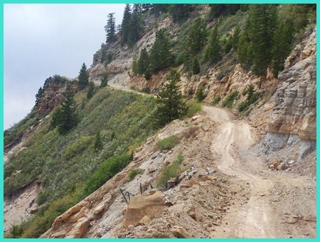
|
|
advertisement |
|
|
advertisement |