| |
| |
Montezuma s(u) Road surfaces in Nevada are often
so unpredictable - a fact that makes me
appreciate the road over this summit even more,
which has a very nice and predictable surface.
If there is such a thing as a great gravel
summit, this is it. And the desert scenery
shines too.
This first part of E Railroad
Springs Road is a very pleasant ride through an
ever changing desert ravine. Great views of flat
topped Mt Jackson appear to the south, together
with all sorts of inviting turnoffs to explore.
The profile continues direction west. When in
doubt it stays on the heavier used track. Slowly
the track climbs further and enters another low
ravine, with a hint of sand under the wheels, but
nothing close to as debilitating as the south
leading E Railroad
Springs Rd. 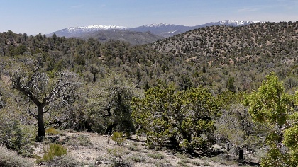 At the
next junction there is a great view of the White
Mountains in California. What a contrast they make
to the garden of cacti in the foreground. The
profile stays right here, heading straight for
Montezuma Peak. At the
next junction there is a great view of the White
Mountains in California. What a contrast they make
to the garden of cacti in the foreground. The
profile stays right here, heading straight for
Montezuma Peak. The top is dense Juniper forest. The
foot paths to Montezuma Peak on the west, and a
microwave facility to the east are obvious from
the well defined summit. The map labels Montezuma
Spring, Montezuma Mine and the site Montezuma all
close to the summit, slightly east of here.
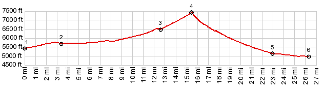
Montezuma Peak, a typical desert triangular shape,
reaches 8353ft. From North. (described
downwards). A steep downhill over a remarkably
non-rocky surface speeds the cyclist direction
alluvial fan below. Once it is reached, it also
turns out to be a viewing platform direction west
and the White Mountains. Straight as an arrow the
bike speeds north. The next big event in the ride
is a slight change of direction, now heading more
easterly towards a dry lakebed with an immense
desert stretching out behind it. At the end of
gravel the profile turns right onto paved Silver
Peak Rd. The profile ends at a low point before
the road starts climbing again direction
Goldfield.
Dayride with this point as
highest summit
PARTIALLY PAVED / UNPAVED ( < E Railroad Springs Rd - Silver Peak Railroad Rd(sh) | Saulsbury Summit > ) Montezuma s(u) , Goldfield Summit: East Railroad Springs Rd near junction with I95 > up East Railroad Springs Rd > Jackson Wash Rd north > Montezuma s(u) > Silver Peak Rd east > Alkali > I95 north > Goldfield > I95 north > East Railroad Springs Rd back to starting point: 46.7milesf with 3310ft of climbing in 5:33hrs (Garmin 32x m5:23.4.29) Notes: desert flat fix solitaire - ride was moderately slow and hot 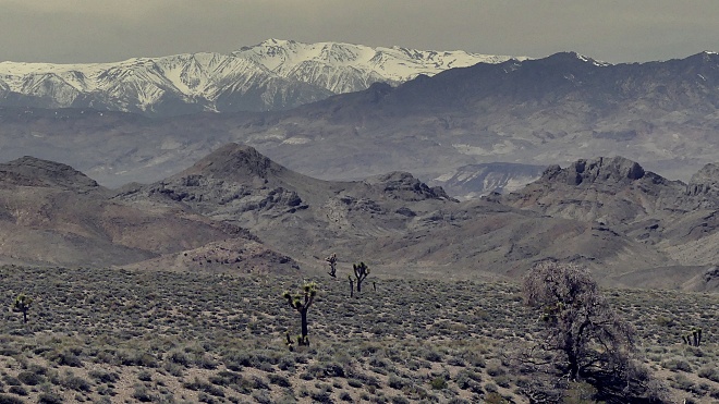 |
|
|
advertisement |
|
|
advertisement |