| |
| |
East Railroad Springs Rd
via Silver Peak Railroad Springs Rd(sh)
This is a small shallow summit in
the Goldfield Hills, desert country south of
Goldfield. Road surfaces can change quickly and
without warning in Nevada. What was a fast aerobic
spin can turn into a exercise in paddling, in
minutes without warning. This road is not quite
that bad. But there are a few places which it
helps to know beforehand.
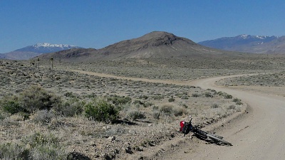
From South. (described
downwards). This view from up here is the most
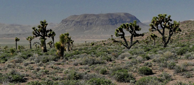
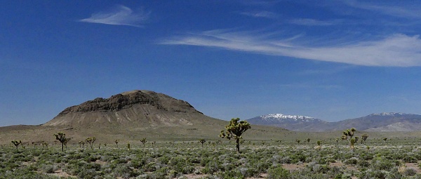
impressive along the way, A line, straight as a
ruler heads southeast toward a solitary mesa.
threading between a sprinkling of catci along the
way. Just because this road is straight
does not mean it is predictable - far from it.
This gentle decent starts out lightning fast only
to sink into depths of sand. These sandy stretches
are often pretty long and come up unpredictably.
They are a good argument for wearing a helmet,
even if it is too hot for that - and it is too
hot. The longest sandy stretches are roughly
halfways before reaching Mt Jackson - the
dominating mesa in the distance. After that the
surface turns perfect for a fast spin again I took
roughly 2 hrs and 10 minutes for these 15+1./2
miles between the top and the jct with Nv266.
Fatter tires will require less time. The profile
follows this paved desert highway back down to its
jct with I95.
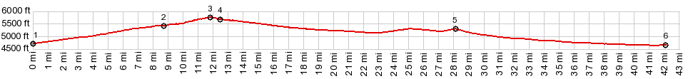
Dayride with this point as highest summit ( < Secret Pass | Montezuma s(u) > ) PARTIALLY PAVED / UNPAVED East Railroad Springs Rd via Silver Peak Railroad Springs Rd(sh) : East Railroad Springs Rd a short distance from I95 > East Railroad Springs Rd west > East Railroad Springs Rd via Silver Peak Raiload Springs Rd(sh) > Silver Peak Railroad Springs Rd north > jct with Nv266 <> out and back on Nv266 west to turnaround point at 6600ft before reaching Lida Summit >> Nv266 east > I95 north > East Railroad Springs Rd west back to starting point: 56.6miles with 2660ft of climbing in 5:36hrs (garmin etrex32x m5:23.4.28) |
|
|
advertisement |
|
|
advertisement |