| |
| |
FR26 Powell Canyon s(u) This pass is located in the Wassuk
Range, south east of Hawthorne, close to the
California line. This town is famous for having
the world's largest ammunition depository. It
makes perfect sense to expect the surrounding
area to be relatively devoid of people. You need
people to maintain the depository. But if there
is a accident, you wouldn't want to blow up more
than necessary. Consequently the entire area is
magnificent isolation in breath taking desert
and mountains. So - to find great isolated
dessert areas on a map, it may be more
productive to look for ammunition depositories
than national parks. On a map this looks like an
alternative to Lucky Boy
Pass. But the two are quite different. As
opposed to Lucky Boy, I would not call this a
bicycle friendly surface, especially the east
side. Also, because of the traverse to access
the climb, the direct way over Lucky Boy Pass is
shorter timewise.
The surface to the mine entrance is
as good as you would expect it to be. There are
even speed limit and "no passing" signs, when the
only vehicles I see the entire day on the unpaved
section are 3 ATVs and about 2 cars. The road
passes the mine and turns westerly downhill, which
makes me check my map instantly. But- the road is
the one I want, it just takes a little more
roundabout way it its objectives, than I had
understood from my first look at the map.
The crest is approximately at a
level where the juniper forest stops, and the snow
on this May 8th begins. 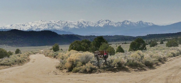
In the lowest section the road runs
parallel to a desert arroyo in close proximity. It
is so nice, that at least it does not run in the
arroyo. In this section a part of the surface is
washed out. Only approximately 50 percent of the
of road width remains (May/23). - Not a problem on
a bike though.
A Dayride with this point as
highest summit:
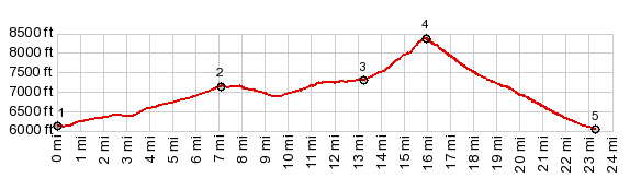
( < FR14 Manhattan s(u) | Sand Springs Pass > ) FR26 Powell Canyon s(u) , Lucky Boy Pass , addtional out and back : jct Nv359 - Lucky Boy Rd > up Lucky Boy Rd > Lucky Boy Pass > jct Lucky Boy Rd - FR26 <> out and back on Lucky Boy Rd to site Fletcher with some additional distance in several directions at that intersection >> up FR26 > Borealis Mine > up FR26 > FR26 Powell Canyon s(u) > Nv359 north back to starting point: 58.5miles with 6160ft of climbing in 8:09hrs (garmin etrex32x m5:23.5.7) 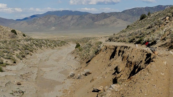 |
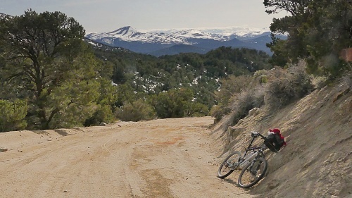 The traverse heading
north takes me more time than I had thought. But
eventually, after a maze of smaller roads
connecting with FR58, the climb towards the ridge
begins. To my surprise this road is not the same
as the prominent traverse above the mine, that I
had seen from below. That must have been a private
mining road. Instead this road, hides behind a
ridge and steeply climbs in juniper forest,
utilizing many curves and general directional
changes. Finally the road heads towards a gap
between Powell Mtn (9524ft) and Bullet Mtn
(9382ft). Though snow covered during May8, after a
record winter of snow, from up here, they make a
gentle appearance, and would offer an easy walk
up. In contrast the yawning distances to the snow
covered Sierra Crest to the west seem impossible
to reach under one's own human power at this stage
of exhaustion.
The traverse heading
north takes me more time than I had thought. But
eventually, after a maze of smaller roads
connecting with FR58, the climb towards the ridge
begins. To my surprise this road is not the same
as the prominent traverse above the mine, that I
had seen from below. That must have been a private
mining road. Instead this road, hides behind a
ridge and steeply climbs in juniper forest,
utilizing many curves and general directional
changes. Finally the road heads towards a gap
between Powell Mtn (9524ft) and Bullet Mtn
(9382ft). Though snow covered during May8, after a
record winter of snow, from up here, they make a
gentle appearance, and would offer an easy walk
up. In contrast the yawning distances to the snow
covered Sierra Crest to the west seem impossible
to reach under one's own human power at this stage
of exhaustion.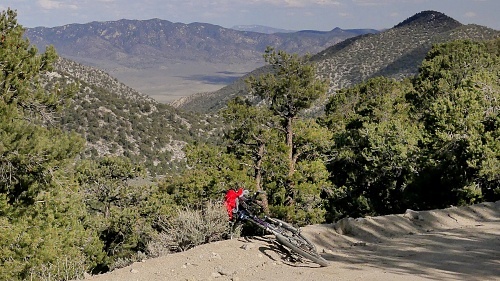
|
|
advertisement |
|
|
advertisement |