| |
| |
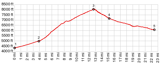
Lucky Boy Pass Monumental fault block ranges,
separated by graben valleys, are a dime a dozen
in south eastern California. Only the highest
ranges and the deepest valleys become famous,
like Death Valley for example. Some distance
east of there, across the border in Nevada is
the Wassuk Range, and I'm guessing few people
are familiar with this name. What is more
exceptional is that the valley to the east is
occupied by a large natural lake, Walker Lake.
The thing that makes this valley even more
famous is the presence of the largest ammunition
depository at least in the US - in the world, if
you believe what's written on signs at the
entrance of the small army town Hawthorne. South east of Hawthorne, crossing
the Wassuk Range runs this monumentally wide,
unpaved road, designed for large haul mining
trucks. This alleviates the most pressing
gravel/mountain biking problem in the area: too
much sand. We wouldn't want to get our truck,
hauling mining ore stuck in the sand now, would
we ? Also - I didn't see any large trucks
whatsoever. Instead the surface is exceptionally
smooth for a Nevada gravel road. I would call
this a very bicycle friendly pass. It also has a
magnifcent view of the main Sierra Crest from
the east side of the summit.
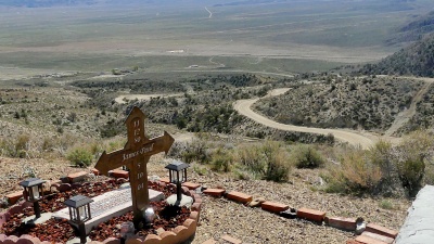
On the way up you can't miss a carefully crafted homemade monument to a military person. He did not get to be very old. The site also has a great overview of Hawthorne and the ground cover on top of all its assorted buried explosives of all types. Eventually the road reaches a rolling surface of sorts. You can only see the upcoming pass during the last short straight away, heading for an apparent edge to the landscape. Cory Peak (10500ft), flanking the pass, seems very rounded and stands in easter egg like isolation
The road reaches a low point of
sorts at the junction with CR3c (or possibly
Nv3c). At this monumental dirt junction in the
desert there is a sign that even includes a few
destination names, such as Bodie, Route15 and
Hawthorne. In this general area is also town site
of Fletcher. It is located on a short road, which
cuts off the junction when connecting two of its
roads. Water across the road marks the spot of the
old town. Today a nice grove of trees are the
result. To facilitate requirements of modern man,
BLM has also erected a parking lot with toilet at
the spot.
|
 From East. (described
downwards) The road turns north and presents a
magnificent panorama in 270 degrees. In the
distance snow covered peaks play with a few
clouds. The road still has this monumental width.
A ridge of piled up dirt on the west side serves
as a guard rail of sorts. It becomes clear that
the decent into this high mountain desert park is
a lot smaller than the climb just finished. The
sinusoidal road down stands in contrast to this
idea. It makes the decent look much larger and
complicated than it actually is. Once down in the
park, starting at the junction with FR27 to the
Borealis Mine and
From East. (described
downwards) The road turns north and presents a
magnificent panorama in 270 degrees. In the
distance snow covered peaks play with a few
clouds. The road still has this monumental width.
A ridge of piled up dirt on the west side serves
as a guard rail of sorts. It becomes clear that
the decent into this high mountain desert park is
a lot smaller than the climb just finished. The
sinusoidal road down stands in contrast to this
idea. It makes the decent look much larger and
complicated than it actually is. Once down in the
park, starting at the junction with FR27 to the
Borealis Mine and 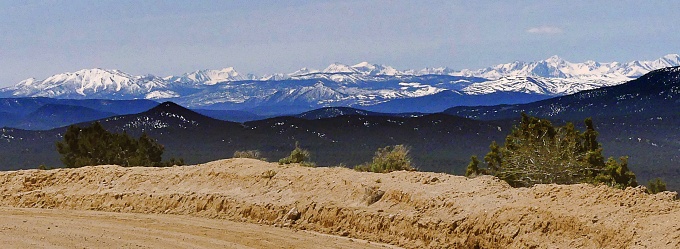
|
|
advertisement |
|
|
advertisement |