| |
| |
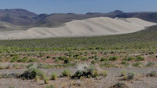
Sand Springs Pass US50 hops over a number of summits
on its way westward from Fallon to Austin to
Ely. It starts out with this one. Slowing
westward winds have deposited a huge sand dune
at the edge of the plain, that Fallon sits on. On the map another summit point
follows after this one heading west. It is
labeled Drumm Summit. However it does not even
come close to having the 500ft minimum elevation
gain on the other side. Instead the road just
keeps on climbing towards Austin ever so
imperceptibly.
From East. (described
downwards). On the initial decent the
quintessential Nevada east-west summit experience
happens. Suddenly the road ahead comes into sight.
It crosses the valley ahead with a line, as
straight as a ruler, very close to perpendicular
to any and all mountain ranges in site. The road
remains dangerously rumble stripped. I had a very close call here on the
way down with a double trailer truck. He announced
himself with blaring horns, maybe a 200ft behind
me. The opposing lane was occupied by another
oncoming trailer truck. I managed to stop the bike
in the dirt next to the road. He sped by me with
at least 70 miles an hour, ceding not an inch of
the road, blaring his horn. There were just a few
inches between me and the truck. l'll be glad when
the human species is finally finished on this
planet, and with it incidents like this. That being said, the traffic decreases to a minimum by the time you get past the profile and closer to Austin. So that anything like what happened to me would seem very unlikely, the further east you get. Also - the shoulder starts to be ridable with a paved over rumble strip, just past the intersection with Nv722 Dayride with this point as
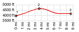
highest summit:
COMPLETELY PAVED ( < Lucky Boy Pass | Earthquake Faults Road s(u) > ) Sand Springs Pass x2 , additional out and back: Sand Mountain Rec Area <> US50 east <> Sand Springs Pass <> Drumm Summit(shp) <> turnaouround point ~7miles east of jct with Nv722 to Carroll Pass: 65.3miles with 2530ft of climbing in 5:14hrs (garmin etrex32: r5:23.5.16) |
|
|
advertisement |
|
|
advertisement |