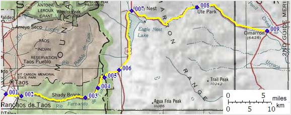
| |
| |
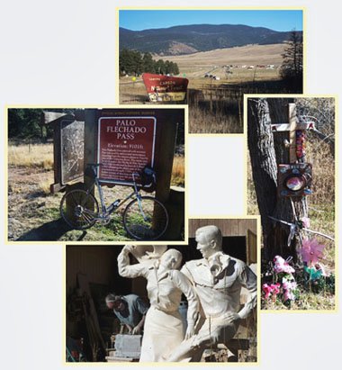
Palo Flechado Pass
A sign that spring has come to Denver used to be that a group of Denver Bicycle Touring Club members packed their bags to go cycling around Taos for three days. A high point of this tour was riding over this pass. This still happens sometimes. But other things have changed. The traffic up from Taos is fairly heavy now, while the road is still as narrow and shoulderless as it has always been. Another high point of these bicycle club tours would be a visit to the Taos Indian pueblo. The last time I tried cycling there I was stopped and told to turn around since cycling to the pueblo has now been made illegal by the tribe. Mind you - driving there is still okay - especially if you are going to the casino to gamble away your money. But cycling, and having an actual interest in the native cultural sites by visiting them, is apparently no longer okay.
But back to Palo Flechado Pass.
It's still a magnificent climb to a green world
above, and if you have an interest in old Taos
history, which after all is older than most
anything else American, you are not likely
to be bothered by other things, at least during
a first time visit. As for repeated training
climbs, I think there are better options.
Approaches From East. Coming from
points south like the US Hill summit,
the quickest way to the pass is by bypassing
downtown Taos itself and turn right onto Paseo del
Canyon, at a spot that looks like any suburb in
the USA, where the natives get their fill of Taco
Bell burritos and Kentucky Fried chickens. The
road climbs several hundred feet before ever
entering the canyon, and from the top of this
alluvial fan looking north, the Sangre Cristo
Rangs shows off one of their more magnificent
peaks, located behind the pueblo and appropriately
named "Pueblo Peak". There is a short downhill
where the road joins a more direct route from the
north part of downtown Taos and then enters the
canyon. As mentioned, traffic can pretty much span
the gamut from the recent earthship immigrant, who
insists on giving you both lanes of the road, to
the low rider with a blinding paint job and a
decal of christ in thorns on the back - with the
usual wide variety of truck driver behaviors
thrown in. After passing Valle Escondido traffic
diminishes considerably since most of the tourist
establishments, art galleries (like the sculpting
business pictured below) and businesses
capitalizing on the enchanted circle slogan are
now behind. The road remains in forest without far
views over one switch back to the top. Here an
official historical summit marker elucidates the
fact that the name "Palo Flechado" originates
either from the name of a similarly sounding
Apache band, or the habit of "shooting the
remaining arrows after a successful buffalo hunt
into a tree on a pass". Should this be the case I
would think they have found a lot of arrow heads
here. But the sign doesn't go into that. From West. (described
downwards) It is a short, fast descent with many
surprising tight turns into the Angel Fire resort.
In spite of the fact that the valley is drier and
barer, you can't see it until you are down. The
road continues barely descending to Eagle Nest.
The views of the backside of Wheeler Peak, New
Mexico's highest mountain, are actually more
interesting than any views from the pass. Here
Eagle Nest Lake gathers the water run off from the
east side of the high Sangre de Cristo Mountains
and makes a getaway through Cimarron Canyon to the
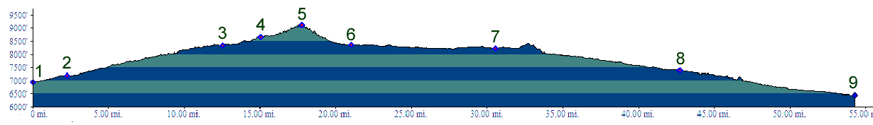
plains below. The profile also includes the short
climb to the top of Cimarron Canyon, followed by
the scenic, shoulderless descend to the town of
Cimarron.
Dayrides. (paved): A loop ride, starting at Coyote Creek state park > Mora > Holman Hill Summit > US Hill Summit > Taos > Palo Flechado Pass > Angel Fire > back to the starting point measured 105 miles with 6500 ft of climbing in 7:4 hours (r2:07.10.25). History. Spanish Colonial Times. Even the date when history first records that Palo Flechado has existed for countless generations predates what is often called North America's oldest city - that would be Saint Augustine in Florida. 250 Spanish horsemen, 70 footmen and several hundred friendly Indians had come over Glorietta Pass in search for more gold to rob. The winter of 1540 was closing in on them as they made preparations to winter along the pleasant winter climate of the Rio Grande. But there was still time to reconnoiter the area north, and so Coronado's captain Hernandez de Alvarado brought back news not of gold, but as a matter of not very great importance - news of the existence of Palo Flechado Pass and two others close by to the north, Apache Pass and Osha Pass. The Taos pueblo Indians used all these tracks to trade with and escape from nomadic Apaches who would visit the area from the east. More than 150 more years go by until history records a actual crossing by Spaniards of Palo Flechado Pass. Santa Fe had already been established as the capital of New Galicia province for a hundred years. But the colonialists were too busy feuding and putting down revolts to do much exploration for its own sake. We are told that the pueblo revolt of 1680 was sparked by a number of Indians running off to the Arkansas River rather than to continue building Christian churches for the Spaniards. Don Juan Archuleta pursued these Indians over Palo Flechado Pass, down the bare valley on the backside of Wheeler Peak and through the gap of the Cimarron River ( then called Taos Gap ) to the plains below, northwards into Colorado. Two years later, 1682, the Spaniards felt threatened that they were not the only colonialists on the continent. After all, a French party had descended the Mississippi to its mouth the same year. Could a French invasion be far behind ? The Spanish answer was a "shock and awe strategy". Awe the Apaches, shock the Frenchmen if there were any, and bring back some runaway Picuris Indians on the side. Of course there weren't any Frenchmen to awe. But Captain Juan de Ulibarri did get a chance to cross Palo Flechado Pass. Subsequently the party headed for Raton Pass in Colorado, but was diverted 15 miles to the north by hostile Comanches to Long's Pass. In 1719, concern about Frenchmen descending the Rio Grande like they had the Mississippi prompted action again to ride towards the plains, avoiding any exploration of their western boundaries at all costs, or so it seems. The area west of the Rio Grande remained a mystery, and would be until de Anza founded San Francisco in the 1770s, when the Spanish would have reason to seek a path west. And so the objective behind crossing Palo Flechado Pass again, was looking for Frenchmen and revolting Indians. This time a contingent of over a hundred colonialists and supporters, headed by Pedor de Villasur, headed all the way into what is now eastern Nebraska. Still there was no sign of the 6000 French men poised to descend the Arkansas to the Rio Grande. In Arkansas 33 soldiers were killed, not by Frenchmen, but by Pawnee Indians. The news brought back by the survivors managed to curb Spanish anxiety about the French. In 1763 the whole French-Spanish colonial dispute was settled, at least on paper, when France handed over today's French Canada to England and the west side of Mississippi drainage -wherever that was- to Spain. Nobody really knew just what the west side of the Mississippi drainage encompassed. In any case, efforts to strengthen the Spanish colonial position was no longer directed solely at the French. Palo Flechado Pass remained the principal highway to the east until de Anza rediscovered La Veta Pass (a variation of today's North La Veta Pass), naming it Sange de Cristo Pass, while returning home from yet another Indian chase. The new route to the east went up the Rio Grande and crossed only one pass, rather than Palo Flechado and Raton Pass. By 1818 the Spanish empire in New
Mexico had become a shadow of its former self. The
main concern now was invading Anglo Americans, not
Frenchmen. On paper the land north of the Arkansas
River was sold to the Americans by the French with
the Louisiana Purchase. That boundary was still
north of Taos, but still took much of what the
Spanish saw as their territory. The situation was
exasperated. when news of a report in French,
detailing various pass routes to New Galicia for
the enemy, reached the Spanish minister Luis de
Onis. Again the Spaniards crossed Palo Fleachado
Pass to defend the homeland. Acting governor of
Santa Fe, Facundo Melgares knew that the real
danger to Spanish power was from within. But
he still hauled two rusty canons onto Palo
Flechado Pass, and built a mud fort on what is now
Pass Creek Pass.
But before the Spanish got a chance to fire the
two rusty canyons in defense of the empire, the
Mexican revolution came from within. The governor
of New Mexico smoothly shifted from one king to
another, stayed in power, but hauled the two
canons off the pass and let the mud fort dissolve
in the rain. back to
New Mexico's Summits and Passes by Bicycle |
 Tours
Tours|
|
advertisement |
|
|
advertisement |