| |
| advertisement |
| -------- |
| advertisement |
|
Holman Hill summit
The most imposing view
involving this summit just may from the
bottom, and not from the top. Looking east
from the town of Mora, the Sangre de Cristo
mountains are a green eminence with a few
teeth like cliffs eroded into its top row of
giant green gums. However the road to the
summit never comes close to this area, and
instead diverts to the right into a verdant,
green valley.
Except for a few locations mentioned below, there is no road shoulder, but the road is wide and traffic is relatively sparse, so that it makes a pretty good cycling route anyway. The summit is identified in the appendix of Marshall Sprague's book "the Great Gates".
Approaches From East. It is worth mentioning
that NM518 below Mora and below the starting
point of the profile is rumble stripped and
difficult to bicycle. However the initial
miles upwards of Mora have a wide shoulder, on
which the cyclist can safely enjoy the ride,
marvel at all the shining chrome on the car
wrecks displayed in the yards, savor the smell
of wood smoke on a late October morning, or
just count all the disposed Bud Light bottles
next to the road. This scene stretches through
Cordillera and Cleveland to Holman. Here NM518
leaves the Mora valley, the shoulder ends and
the climb begins in earnest. It is a green
scene all the way to the top, something that
could be straight out of Appalachia. At one
point the road near the summit comes into
view, and gives the impression that this is
quite a climb wherever it is. An alternate
dirt road approach which looks like an old
highway merges with the modern road. Gaining
altitude the road meanders through high
forested meadows and then traverses to the
top. Approaching the summit the distant
straight drop-offs of Hermit Peak form
an interesting landmark. There is no official
indication of a summit. But the viewshed
changes dramatically to a few bread loaf like
mountains to the west, with their rounded tops
raising above timber line.
From West. (described down hill). It
is a long, shallow, straight descent. Brakes
almost seem like optional equipment for this
roll. The road passes many resorts with a
strong rustic quality, one of them named "el
Lodge". I wonder how you pronounce "Lodge" in
Spanish. During my traversal on a late
October, early afternoon, the temperatures
became surprisingly colder as I lost altitude.
The long roll ends at the junction with US Hill summit.
Alternatively the ride can also continue for
more downhill interuptus to the Rio Grande. Tours Dayrides. (paved): A loop ride, starting at Coyote Creek state park > Mora > Holman Hill Summit > US Hill Summit > Taos > Palo Flechado Pass > Angel Fire > back to the starting point measured 105 miles with 6500 ft of climbing in 7:4 hours using a Vetta cycle computer with altimeter (r2:07.10.25). (MTB+paved): Another loop ride from Coyote
Creek State Park > NM434 > FR 76 summit(u)
> Tres Ritos > Holman Hill summit >
Mora > Guadalupita > back to the
starting point measured 84 miles with 6000ft
of climbing in 7:4 hours, using a VDO MC1.0
cycle computer (m3:07.10.27).
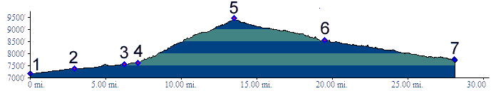
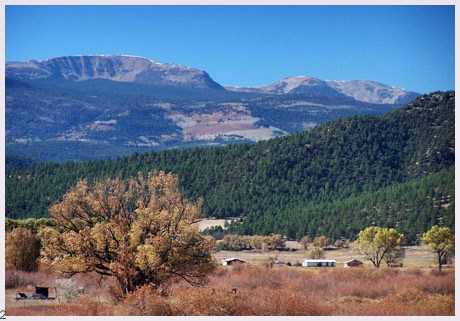
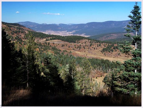
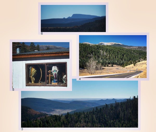
pictures: 1: from summit looking
north east, 2: Sangre de Cristo range from
Mora, 3: approaching summit looking east, 4:
summit looking west, 5: town of Mora, 6 Hermit
Peak to the south back to New Mexico's Summits and Passes by Bicycle |
| Connecting Routes |
| START-END WEST - PAVED - US Hill summit (eastern approach) |