| |
| |
FR76 Osha Pass s(u)
Osha Pass is fairly obscure
crossing in the Sangre de Cristo Range ( but maybe
not by New Mexico standards ). It is located a few
miles south of Palo Flechado pass, east of Taos.
In spite of being nearly forgotten, this is an
ancient crossing with an fascinating history. This
descriptions covers the most obvious route over
the pass, which is not the most direct and also
goes a few feet higher.
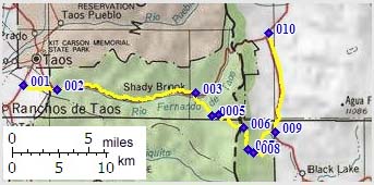
From West. One route to Osha Pass diverts from US84 up Palo Flechado Pass at the turnoff to the Valle Escondido Resort. After elaborate golf course cycling the route follows County Road north out of the development. Less than half a mile before County Road crosses onto private land, FR70 heads east up a steep ascent. A sign labels the road as dead end. There are mutliple ways to the summit in the myriad of forest roads. One way is to stay left uphill at the first fork, then right at the next fork where there is a FR70 sign a short distance after the turnoff. After that, follow the most traveled paths. The top is in an open subalpine meadow surrounded by forested hills. Signs near the top point to two different routes to Apache Pass. This is where the picture was taken. From East. Again there are multiple
routes to the the top. One of them follows the
main road south out of the Angel Fire Resort. The
route turns onto, at times boulder paved, FR76 and
follows it to a small sign advertising the route
to Osha Pass ( the only Osha Pass sign along the
entire route), pointing to a dirt double track
that has been blocked.
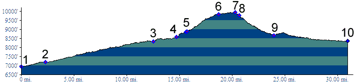
Dayrides. A ride starting from a camping
site near Taos to the Valle Escondido Resort,
crossing over the pass to Angel Fire, and
returning over Red
River Pass, Questa and Taos, with several
additional spurs measured 110 miles with
8210 feet of climbing. The ride was planned with a
return from Red
River Pass over "Bull of the Mountain" trail
( crossing a sholder of Wheeler Peak ) to the Taos
ski area. Some old maps indicate a through going
road at this point, that does not resist. As far
as I can tell, that route is not bikable, and in
any case, much too rough and long. A more
reasonable day tour would have returned over Palo
Flechado Pass.
History The seven miles south of Palo Flechado Pass contain two additional crossings of the Sangre de Cristo Range. Osha Pass is the southernmost in the trio, with Apache Pass in the middle. Osha, the pass above a golf course, without a
sign on top, is older than what is often called
America's oldest city, St. Augustine in Florida.
The Taos pueblo, also a city, just not an anglican
city, entered european consciousness when Coronado
arived in 1540, at least 20 years before St
Augustine was founded. At that time Palo Flechado
Pass was the ancient pueblo highway to the east.
Osha and Apache passes were used by the pueblo
inhabitants when raiding Apaches occupied the main
road. back to
New Mexico's Summits and Passes by Bicycle |
 Approaches
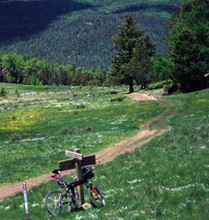 Tours
Tours|
|
advertisement |
|
|
advertisement |