| |
| advertisement |
| -------- |
| advertisement |
|
Glorieta Pass
It has been written that
the Santa Fe Trail crossed only one mountain
pass, and by that the writer meant Raton Pass, not
this one, and that even though crossing
Raton Pass on the Santa Fe Trail was only
optional, while crossing Glorieta Pass was
mandatory. But it is easy to see why the
writer neglected to designate Glorieta Pass
as a mountain pass. I25 just barely
skirts across the southern end of the Sangre
de Cristo Mountains. Here the range looks
very different from its 14000 foot peaks in
southern Colorado. On its southern end of
the range a series of wedge shaped, forested
mesas merge with the prarie hills below.
Even if crossing the pass isn't exactly a
climbing workout, this is an excellent
training ride, especially the eastern side
which has a frontage road as far as the
Glorieta turnoff.
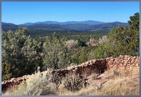
The area within a few miles
of the top of the pass was the site of one
of the most powerful early pueblos. The
history of this pass begins with the history
of civilization in America. A national
historic park along the way tells the story.
 Approaches
From East. With so many rolling hills
along the road it is difficult to agree on a
point where the approach starts. I25 crosses a
major hill just east of San Jose, from where
on it parallels the Pecos River some distance
to its south. At this point NM3 also turns off
the Interstate to roll along the valley of the
Pecos downstream as far as Villanueva. The
profile begins on the I25 service road, just
short of its junction with NM3 where it
crosses the San Miguel ditch. By the way, NM3
is an interesting ride in itself, along old
decaying adobe houses of Mexican origin, mixed
in with newer buildings. The frontage road has
little to no traffic, and it rolls along a far
distance from the interstate. There is no net
gain in elevation until the service road
switches from the north to the south side of
the highway. To the south a mesa forms a low
rim that seems to go on forever, while to the
north the green rolling hills recede in gentle
waves to a narrow line of rocks above
timberline. These rocks are so far away that
even on a clear day they seem to be obscured
in haze. This peaceful frontage road cycling
lasts till Rowe, which is the turnoff to the
settlement of Pecos and the Pecos pueblo
historic park. The cyclist can make the small
detour on a road without a shoulder and quite
a bit more traffic, or continue on the
spacious shoulder of the interstate. The short
detour rejoins the interstate a mile or two
below the summit. After so many rolling hills
you might expect a flat nondescript top. There
is however a clear ridge top with a pronounced
uphill on the last mile. There is no sign on
top.
From West. (also described upwards). The description starts in Santa Fe, but the profile begins later in Canoncito. The route is even less "mountain pass" like from this side. Santa Fe's plaza area is located along the rim of the plate shaped valley. The roads named "Old Las Vegas Trail" and "Glorieta Trail" have bike lanes most or all of the way out of town. "Old Santa Fe Trail" ( another road ) is a narrower two lane road with a correspondingly narrow shoulder. It dead ends in the hills at a picturesque upscale village, unless you take an easily missed left turnoff back down to Old Las Vegas Trail. The shoulder on Old Las Vegas Trail
deteriorates in condition so that cyclists are
forced to ride in the traffic lane after a few
miles (Nov/07). This long straight road rolls
along on the left side of I25 to the Apache
Canoncito area. The total elevation gain up to
this point is not worth mentioning. From
Canoncito the route continues on the shoulder
of the interstate to the top.
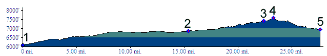
Tours Dayrides. An out and back ride from Villanueva State
Park, across the pass, partly down the other
side to the Canonicito at Apache Canyon exit
on the west side, including the detour through
Pecos and its historic park in one direction
measured 94 miles with 4200ft of climbing in
6:4 hours, including a few extra miles on
frontage road dead ends. From the other side, a ride from
Hyde Memorial State Park, to the dead end on
Old Santa Fe Trail, continuing over the pass
to Glorieta, and returning via Rowe and Santa
Fe measured 87 miles with 6000 ft of climbing
in 6:4 hours. About 2300ft and 19 miles of
that are involved in the out and back section
from Hyde Memorial State Park to Santa Fe.
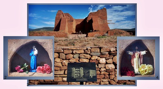
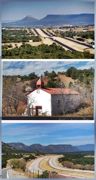
Spanish Colonialism. Indians living in pit houses in this area date all the way back to 800AD. In 1584 Spanish conquistadors "discovered" a well planned frontier fortress with five story high buildings and perhaps 2000 inhabitants. At this time the pueblo was roughly a hundred years old. When the Spanish arrived the 16th century pueblo culture was relatively powerful and wealthy, because their geographic position allowed them to trade between two different cultures. To the west across the pass were other pueblo dwellers with their corn, beans, squash and cotton fields, pottery and large walled houses. Down the pass on the east side lived nomadic Indians, mostly Apaches, who came to trade their buffalo products, flint or slaves. But Coronado and the early conquistadors had little interest in such things. They were after more gold after having so successfully plundered Aztecs and other south American cultures. Pecos Publo welcomed Coronado's lieutenant Alvarado with his Spaniards at first. As their intention became clearer the Pecos Publo people cleverly told Alvarado of golden cities to the east. And so the conquistadors toured the plains all the way to central Kansas, until realizing they were had. They were not happy Spaniards, and after a miserable winter on the Rio Grande returned to Mexico City. The truth was, there was no gold here. But settlers could farm the area, and so the second wave of Spaniards came to colonize and convert 60 years later. To this purpose New Mexico's most imposing mission church was erected just south of the pueblo with towers, buttresses and pine log beams hauled from the mountains. Its remnants are shown in the picture 3. Forced labor and mandatory tributes resulted in a full fledged pueblo revolt in 1680. But 12 years later Pecos pueblos welcomed the Spaniards back and even helped them in retaking Santa Fe. During the next century the pueblo population was reduced by other enemies, disease and Comanche raids. The position of the pueblo on the boundary between two other cultures had also changed. The Spaniards had displaced many Comanches to the east of Pecos Pueblo by establishing their own towns in this area. By the time trade started flowing on the Santa Fe Trail in 1821, the mission church had stood empty for over 15 years and nearly all inhabitants had left. Santa Fe Trail (<Raton Pass (Co)) Meanwhile the Mexicans had their own revolution to liberate themselves from Spain and put themselves under a new emperor, Iturbide Augustin I. New Mexico on the fringe of Mexico made the transition smoothly. The difference between before and after was mostly academic. Conditions with Angloamerica did improve however, and so the time was right for a man visualizing large scale trade between Santa Fe and Missouri, The person in the right time and space was William Becknell. In 1824 he left Saint Louis with twenty four four-wheeled carriages, 50 horses and mules and various other supplies to trade with New Mexicans and Indians along the way. He traveled by way of Raton Pass and crossed into Santa Fe via the Glorieta Pass area. He was welcomed warmly and so began an era of trade between Spanish and Anglican America. Already the next year's caravan tried to bypass Raton Pass in favor of a more dangerous dessert route via the Puragatoire River. But there was no route more favorable than Glorietta Pass, which detours slightly to the south of Santa Fe. Mexican War. In 1846 the expanionist movement in America was in full swing and the US tried to conquer New Mexico. The most expeditious route was still the same: over Raton Pass and onwards over Glorietta Pass. General Stephen Watts Kearney was accompanied by the largest crowd of white people ever seen in this part of the Rocky Mountains, along with one hundred supply wagons and twenty two cannons. The general sent news ahead of the irresistible force about to descend onto Mexican New Mexico by way of diplomats and scouts. Would governor Armijo of New Mexico stage a defense at Glorietta Pass ? No he would not. Instead the overwhelming force had time to take notes on the old brown pueblo ruins, decaying in the sunlight on top of Glorieta Pass, and then still march into Santa Fe without fight or defense. The Civil War Years (<Raton Pass) But a major battle of sorts was fought on the pass after all. The occasion was the civil war, which had finally come to the Rocky Mountains in 1862, when General Sibley captured Santa Fe for the confederacy. Coloradoan fears that confederate General Sibley would soon march on Denver were not taken seriously back in Washington. The result was a Colorado grassroots army, called the "Gilpin's lambs", after Governor William Gilpin. His lambs were bar tenders, preachers, lawyers, con men, shoe clerks, pimps, actors and mule skinners, lead by a Methodist Episcopal preacher. Again the route from Denver was over Raton Pass, and again all the action happened on Glorietta Pass. The badly outnumbered Reverend Major Chivington won a strategic masterpiece of a battle against an overwhelming force of Texans. Howling like Blackfeet, sliding down a mountain side, slipping, crashing from pinon to pinon, they were able to ambush a supply train in the La Glorietta Pass area, and thus destroy a majority of ammunition, wagons, medical supplies and saddles that the confederates would have needed for an invasion of Colorado. There was little else to do for the confederates but burry their 70 dead, and retrieve their wounded to Santa Fe. Thus ended the Civil War for Colorado, and the role it played in its mountain passes. Pictures: Pics 1 and 3 taken at the
Pecos National Historical Park, pics 2 and 4
taken at a private residence at the Apache
Canyon exit, pic 6 also taken near the Apache
Canyon exit, pics 5 and 7 taken on the eastern
approach. back
to New Mexico's Summits and Passes by
Bicycle |
 History