| |
| |
Old Raton Pass Old Raton Pass is in many
ways the oldest and most historic mountain
pass in Colorado. However, since much of
it is no longer publicly accessible, more
about the history is on the Raton Pass
page, and this page is more of a
description. In the book "Passes of
Colorado" Raton Pass and Old Raton Pass
are not treated as separate points, and
that even though it lists three different
historical versions of Monarch Pass (for
example). But the old historical pass road
does reach a different summit point.
Besides the highest points are actually
just across the boundary in New Mexico.
The entire old pass road on the south side
is now on private, gated land, as I
discovered during my last visit. While looking for the route
again recently, I joined the conversation
between a man who has lived in Raton for a
long time and a couple who had just moved
here. "Back then you could drive from here
to Colorado." he observed - "That would be
cool" added one of the newly arrived
residents. "But then this guy from Texas
bought it up and closed down all the
access". In all fairness, the whole area
around Raton Pass is probably the most
private, heavily gated and access
restricted area I have ever seen in
Colorado, and it is hard to imagine this
as a result of only a single land owner. I
imagine public interest in this area is
fairly large. The Santa Fe Trail crossed
here, an old historic rail line crossed
here, reincarnated as a still functioning
railroad. The description below is a
mixture of old photos and what I remember
of a ride several decades ago, updated
with what one can expect to find now as
told by the old man from Raton. The
profile was fairly easy to reconstruct.
All the roads still show up on modern
maps.
From
South. Past that the road is more
heavily used and curves around to the east,
direction new Raton Pass summit. More gates
and junctions confuse the situation further.
A right leads down to the Port of Entry at
the I25 Raton Summit, a left goes down to
another farm with closed access. It is
possible to bushwack with a bike to I25 from
here. More heavily used private roads
continue on the south side of the farm. But
the reconstructed profile goes down I25 on
this side.
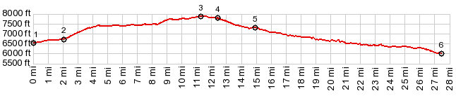
Dayride with this point
as highest summit
PARTIALLY PAVED / UNPAVED ( < Co78 Wet Mountains s(u) | Laughlin Peak / Blosser Gap Rd s(u) > ) Old Raton Pass , Raton Pass : low point at southern end of Raton > Raton with several city street detours > Moulton Ave west > a variety of unmarked dirt roads north > Old Raton Pass > more unmarked roads north to near Wooton exit > I25 north > several sightseeing loops around Trinidad > service road on east side of I25 south > I25 south > Raton Pass > several sightseeing loops around Raton > back to starting point: 55.4 miles with 4250ft of climbing in 5:35hrs (r4:12.5.14s[y1,y2]) |
 After that the
road continues unabated, near the edge of
the gentle mesa, apparently to another gate.
The road continues through juniper forest to
a turnaround circle and a ditch of sorts,
where a land boundary has been transformed
into something resembling a WW1 combat
ditch. Apparently this marks a boundary
between two private land owners. On the
other side the once through going road
continues again. Further along the way, I
remember an old adobe building next to that
road. A sign above the entrance reads "Fort
of Welcome", apparently a relic from days of
the Old Pass Road, during the early days of
automobiles. Today the greeting stands in
stark contrast to reality. Apparently it is
fenced in now, probably the best for its own
protection, even if the area is no longer
accessible. Past that the road splits, and a
small detour leads to a local high point
with the best views along the route. This
small detour is included in profile and
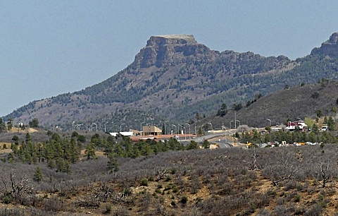
pictures. You can also see I25
cresting at the new Raton Summit with an
especially stark image of Fisher Peak behind
it. This route rejoins the more heavily used
road after this view. But the summit
elevation of Old Raton Pass is still a
little higher, and slightly south of Co-NM
boundary.
After that the
road continues unabated, near the edge of
the gentle mesa, apparently to another gate.
The road continues through juniper forest to
a turnaround circle and a ditch of sorts,
where a land boundary has been transformed
into something resembling a WW1 combat
ditch. Apparently this marks a boundary
between two private land owners. On the
other side the once through going road
continues again. Further along the way, I
remember an old adobe building next to that
road. A sign above the entrance reads "Fort
of Welcome", apparently a relic from days of
the Old Pass Road, during the early days of
automobiles. Today the greeting stands in
stark contrast to reality. Apparently it is
fenced in now, probably the best for its own
protection, even if the area is no longer
accessible. Past that the road splits, and a
small detour leads to a local high point
with the best views along the route. This
small detour is included in profile and
pictures. You can also see I25
cresting at the new Raton Summit with an
especially stark image of Fisher Peak behind
it. This route rejoins the more heavily used
road after this view. But the summit
elevation of Old Raton Pass is still a
little higher, and slightly south of Co-NM
boundary. |
|
advertisement |
|
|
advertisement |