|
|
|
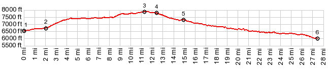
1.START-END SOUTH: low point on the south
side of Raton
2.upper part of Moulton Ave, Raton
3.TOP: 7880ft, point of highest elevation
4.junction between road to top of I25 Raton Summit and
road continuing on west side.
5.profile joins I25
6.START-END NORTH: low point in Trinidad, near park
north of downtown
|