| |
| |
Raton Pass
The mesas of the Raton Hills run
in an unusal direction: east -west. And that
fact made them into the original historical,
natural boundary between the anglo culture to
the north and the more hispanic culture to the
south. These landforms must have remided early
Spanish traders of very large mouse bodies, and
so they named them "Big Mouse Hills". Raton Pass
is the biggest gap in these mountains and it has
been a historical funnel, through which traffic
between these two cultures must pass (unless
they opt for a detour through extremely dry
country). But they are hills, not mountains -
unlike the Sangre de Cristo Mountains, just
barely visible from the pass towards the west.
A ride, largely on the shoulder of I25 is not the best bike ride, allthough perfectly doable. And so for me the two endpoints on this ride become the most interesting things. It's the difference between the two. Both are in one country, but not the same state or cultural background. Trindad and Raton both give the impression of proud county captiols with interesting architecture in official county and private business buildings - both in their own different ways. Raton Pass is an important divide between cultures, but not between watersheds. The passes' proximity to the Arkansas River has shaped its history, in spite of the fact, that as a watershed divide Raton Pass turned out to be unimportant. Both sides of the Ratons are within the Arkansas drainage. The Arkansas River itself flows a hundred miles north of the hills. Other tributaries in New Mexico, most notably the Cimarron and the Canadian, which flow southeast as though to join the Rio Grande, also end up feeding the Arkansas. However this mountain pass ranks higher on the list of cultural divides than any pass in the area. It divides the cultural influence of old Mexico from Anglican America.
From North. A road named "Old Santa Fe
Trail" parallels I25 on the east side leaving
Trinidad. The outskirts of town is marked by the
presence of a Walmart. From here on the official
way up the pass leads onto I25. I had to look
twice at the signs to figure this out. The sign
consists of bicyle with a big green circular edge
around it. If the edge were red, this would be a
European sign for "no bicycles allowed". But it is
green, and being somewhat colorblind this is not
exactly easy to figure out. But dead end service road continue on both sides.
The one on the east side is paved and in close
proximity to the interstate. As of yet I have
always taken it to a point where the pavement ends
and then just switched over to I25. This is
especially easy on the decent because you don't
have to cross any lanes of traffic. The northern most service road on the west side
dead ends in a spot where switching to I25 is not
easily practical. Further south, another unpaved private road runs
along west of the Interstate. Although it runs on
the other side of the river for a while, there are
several options to switch between the two, at
exits and other spots where the two run parallel.
About a mile past the Wooton exit, roads to the
west of the interstate are too far away to access
from the interstate. From here to the top, the road can be pretty
noisy with screaming truck engines. Best to
concentrate on the scenic meanders of the rail
line. An especially scenic curve comes into view
about two miles below the summit. In past
decades it was possible to avoid this section in
favor of a gravel road, swinging in a loop to the
east. From a few steps higher you could catch a
glimpse of the far Sangre de Cristo Range as in
the picture below. You can still see the road, but
you can't use it anymore legally
Instead I25 also becomes noticably steeper here.
The summit has an exit, a weigh station for
trucks, a private campground, a few historic
informational signs about Dick Wooton's old wagon
road and lots of no trespassing signs. The
point of highest altitude is past the sign stating
"leaving Colorado", and just under the bridge with
a sign "welcome to New Mexico". 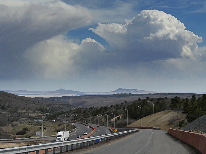 looking into New Mexico from the top of Raton Pass
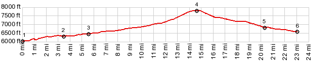
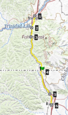
COMPLETELY PAVED Raton Pass x2: Trinidad area with detours > Raton Pass << turnaround point in Raton with detours > Raton Pass a second time: 52 miles (mechanical odometer: (m1:91.05.30 t91_3 34-36) same summit points: Trinidad Lake state park area > Trinidad with detours > Raton Pass > sightseeing loops around Raton > Raton Pass > unspecified detour on Moore Canyon Rd > back to starting point in Trinidad Lake area: 68 miles with 4500ft of climbing in 5:5 hours (m3:07.10.18 _t07_6 1-3 ). Dayrides with this point as intermediate summit are on page: Old Raton Pass 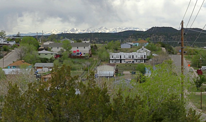 outskirts of Trinidad with the Sangre de Cristo Mountains in the distance History
Raton Pass was the original American pass at the boundary line of two cultures, even though the boundary was not so well defined. To the south was the Spanish province of New Galicia and its sun baked, dusty capitol Santa Fe. To the north - for now - were bands of indians. By 1700 traders in wide brimmed Sombreros and long, clanking spurs were leading mule trains north over (Old) Raton Pass to present day La Junta to trade with indians. In 1719 Pedro de Villasur lead a scouting party over Raton Pass across the plains to the area of present day Platte River Nebraska, where most of them were killed by Pawnees. In 1803 Napoleon offered the American president Jeffereson a real estate bargain, that was too good to pass up, the Louisiana purchase. After that deal, exactly who theoretically owned what, not even considering the people who actually lived there, was a matter of conjecture, and so the boundary between Spain and the American states was thought to be the Arkansas River, or was it the Red River ? This put Raton Pass square inside the area of confusion.
Finding the source of the Red River was not as easy as it sounds nowadays, ecspecially if you ask Zebulon Pike. The actual source of the Red River was eventually found decades later in Western Texas, a long way from Raton Pass. In 1819 the matter gained importance again and the Arkansas River was accepted as boundary between Spanish territory and unorganized American territory to the north. After the Arkansas turns north near Salida (in upstream direction) in the Arkansas valley, a line extending northwards beyond the Arkansas headwaters was accepted as the boundary between Spain on the west and the non united states to the east. In 1822 Raton Pass was still the pass
connecting two cultures. Mexico had won
independence from Spain and what would someday
be New Mexicans were now formally Mexicans. To
the north settlement of the west was driven
ahead forcefully with inital steps being taken
by the expansionist mister Manifest Destiny
himself, Senator Hart Benton from Missiourri.
When the Mexicans dropped the old Spanish
trade ban with the north, Raton Pass was used
by William Becknell for a trading expedition
from Saint Louis on the Arkansas to Santa Fe,
where he sold his goods for seven times the
cost. But Raton Pass was not the only viable
route for this east west route. Already during
the next spring of 1822 he pioneered the
Cimarron Cutoff route, which cut off Raton
Pass in favor of a dry dessert route following
the Cimarron River from the great bend area of
the Arkansas. Both routes became part of the
standard Santa Fe Trail from Saint Louis. The
"mountain division" over the pass was favored
by pack trains and emigrants for whom water
and relative safety was more important, while
the Cimarron cutoff was preferred by more
mobile parties with greater tolerance to
Indian attacks. Raton Pass was also the route of choice for General Stephen Kearny and his "army of the west", in service of the US expansionsit movement. Bent on conquering New Mexico from Mexico, Raton Pass saw quite a bit of traffic during August of 1846, including 100 suppy wagons, twenty howitzer canons and a great many mules
By 1865 traffic on the difficult road was heavy enough that Dick Wooton built a toll road over the pass which operated until the next chapter of transportation began, the building of the railroad in 1878. 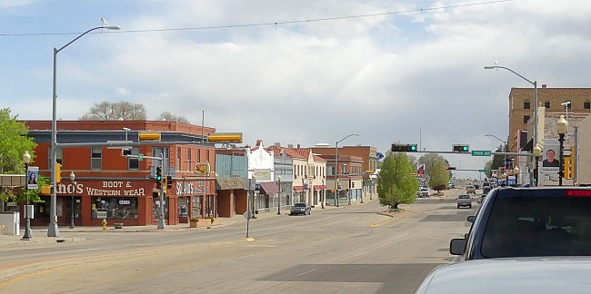 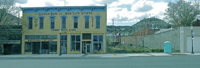 Raton
The Civil War Years ( <Yellowjacket Pass | Glorietta Pass >): During the Civil War years Raton Pass was still the pass between two cultures, but again the culture south of the pass had metamorphosed, this time into the confederate south. Several Colorado passes played a role during the civil war years. The previous pass is this thread, Yellowjacket Pass, was surveyed for reasons directly attributable to the Civil War. The connection between Raton Pass and the civil war, however is very different. It had long been discovered and heavily used. Instead it was the major thoroughfare for an interesting armed contingent, on its way to fight its own version of the civil war.
When Colorado governor Gilpin was refused troops from the union, because he feared that the confederate south would try to take Colorado's gold mines, he did not take it lightly. Gilpin took matters in his own hands as far as fighting the southern invasion was concerned. He organized an army of 1342 gold camp miners, bartenders, lawyers, preachers, con men, shoe clerks, pimps, actors and mule skinners among them. "Gilpin's Lambs", as they were known sarcastically, were headed by a lawyer without military experience, and had a reverend as major, John M. Chivington. It was this unlikely collection of military impersonators, who traveled across Raton Pass to meet General Sibley and his army of fierce Texans in battle.
Railroads (<Old La Veta Pass|Kenosha Pass>): Raton Pass became the second Colorado pass to be crossed by a railroad. At the time the name "Cimarron Pass" was used. The first pass to be crossed by a railroad was Old La Veta Pass. Even before the first railcrossing over a Colorado pass was finished, the dispute over Raton pass had started.
The two adversaries were the the Santa Fe railroad arriving from Kansas, and the Palmer's Denver Rio Grande Railroad from Denver. For some time they had been laying track side by side, south from Pueblo. They knew that when they reached the entrance to Raton pass, only one of them could contiune. Which one would it be ?
Denver Rio Grande's Palmer managed to make more enemies than friends, because he bypassed exisiting communities in favor for his own land development profits. The existing wagon traffic across Raton Pass was controlled by Dick Wooten's toll road across it. When both railroads arrived at the base of the pass, Wooten supported the Santa Fe. He provided armed guards so that the Santa Fe could start grading. Was it because of a dislike of the DRG and Palmer ? The fact that the Santa Fe offered him 50$ a month, for the rest of his life could also have had something to do with it.
Palmer did put up a hard fight for Raton. He managed to get over Old La Veta Pass even faster than the Santa Fe could get across Raton. The two railroads clashed again at the base of another valley, a canyon really, the Royal Gorge of the Arkandas near Canyon City. Palmer forgot all about his original plans, which was to reach El Paso Texas, and beyond to Mexico. A silver boom in Leadville had errupted. That's where the real money could be made. From where he was, the quickest way to Leadville was up the Arkansas, a long southern detour, but a path to the pot of gold nontheless. That time the conflict between the Santa Fe and the DRG became a real war en miniature.
As far as Colorado passes are concerned, Raton was the first and last pass for the Santa Fe. Here the focus shifts to another railroad and another pass, The Denver South Park railroad to Kenosha Pass.
Modern Highways (<Wolf Creek Pass|Ute Pass>): In 1913 Raton Pass became part of the second designated cross country automobile route. In the eastern states the traveler had an atlas of roads to choose from. In the west the "National Old Trails Road" reached Colorado Springs over Raton Pass then continued over Ute Pass, Wilkerson Pass, Trout Creek Pass, Tennesee Pass onwards to Grand Junction, Utah and Los Angeles. |
 Approaches
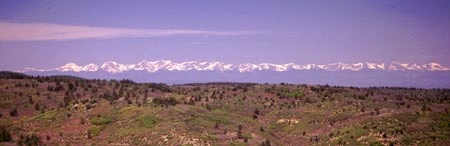
|
|
advertisement |
|
|
advertisement |