| |
| |
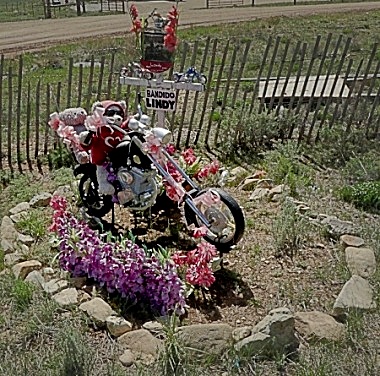
Bobcat Pass This pass is part of an
often cycled two day loop, centered on
Taos. Still - this is New Mexico, and
motorcycle based motifs (like the one on
the right) are easier to find than
roadside pictures with bicycles. There is an almost through going spacious shoulder on the west side of the pass - no shoulder on the east side. But sofar I have never experienced enough traffic that would make this a problem. This popular two day touring loop. goes over two passes. The other one is Palo Flechado Pass
A few mining areas are well
hidden in the deep forest and the road
gently climbs in the bottom of a green
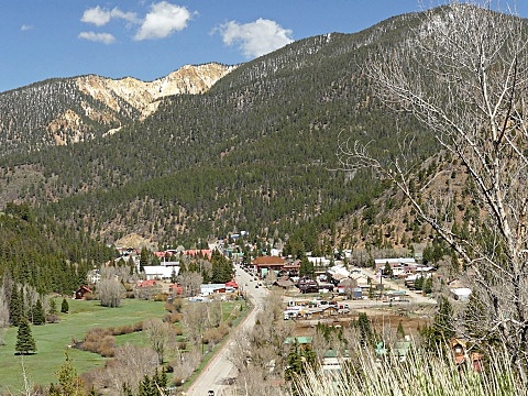
valley. Eventually the road reaches Red
River, a mixture of low key ski / ATV
resort. After that the first real climbing
workout starts, and not far above the ski
town I see my first irresistible picture
taking opportunity, also remembering that
this was the same spot I stopped for the
same picture the first time I rode this
pass.
The top of the pass reaches a
meadow that might be the treeline. But the
spot is nothing special, just a place for an
ATV rental company to park all its vehicles. 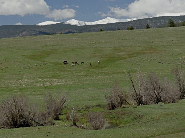 From
East. (described downwards) But
immediately after that the first nice view
of Mt. Wheeler, the highest mountain in New
Mexico shows up on the right. It is the
first of many views, every one slightly
different. In spring Mount Wheeler is a
sliver of white skyline peaks lining the
forested hills below.
Here the profile leaves the
traditional bike route, which continues
direction Taos, and soon starts climbing
again. Instread the profile climbs just
around 150ft and descends along a valley on
the eastern side of the Sangre de Cristo
Mountains. These 150ft are not enough to
make this a separate summit point, but the
elevation difference is easily
underestimated because of the expansive view
that it opens up. A short steep descent leads
into a state park where all camping hiking
and recreating is severely regulated and
charged. It is a nice quiet forest, and
after that it gets only more restrictive.
Past the small community Ute Park the road
crosses into the Philmont Ranch area. This
is an area which an oil company millionair
has given to the boyscouts, who now control
this area in the same restrictive manner as
the oil company millionair did. There are
several named historic pass roads in this
area that are not accessible to public,
unmotorized travel. I guess we are lucky
that they let you stop on the side of the
road. There is no shoulder anywhere on this
descend. And even though there is definitely
more than noticeable traffic, in my
experience the majority of them are
extremely careful and polite. Could that be
the boyscout influence ?
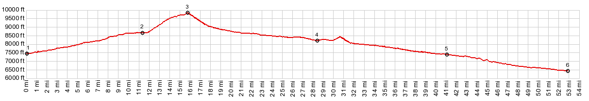
Dayride with this point
as highest summit:
( < Laughlin Peak - Blosser Gap Rd s(u) | Red River Pass > ) Bobcat Pass x2: Goat Hill Campground a few miles from Questa <> Red River <> Bobcat Pass <> Eagles Nest <> US64 east <> Ute Park << turnaround point just east of Ute Park at State Park / Philmont Ranch boundary: 85.4miles with 5750ft of climbing in 7:08hrs (garmin etrex30 r4:21.5.20) |
 That was 36 years
earlier, and that time I got a good group of
riders into the foreground. They were the
riders near the back of the group. They were
the most fun to talk to while riding. These
rides were organized by famous S+M duo
(nothing to do with sado... or maso, but
Shayne and Margaret) for the Denver Bicycle
Touring Club. Now 36 years later, there were
also a few cycling types in the pictures.
But they were the ones in the front of the
pack and passed me at full speed on electric
bikes, followed by a new ostentatiously
painted up van, sporting the inscription of
the private touring company, putting on this
"adventure". Maybe that's progress or
maybe that's just the inevitable and
unavoidable future.
That was 36 years
earlier, and that time I got a good group of
riders into the foreground. They were the
riders near the back of the group. They were
the most fun to talk to while riding. These
rides were organized by famous S+M duo
(nothing to do with sado... or maso, but
Shayne and Margaret) for the Denver Bicycle
Touring Club. Now 36 years later, there were
also a few cycling types in the pictures.
But they were the ones in the front of the
pack and passed me at full speed on electric
bikes, followed by a new ostentatiously
painted up van, sporting the inscription of
the private touring company, putting on this
"adventure". Maybe that's progress or
maybe that's just the inevitable and
unavoidable future.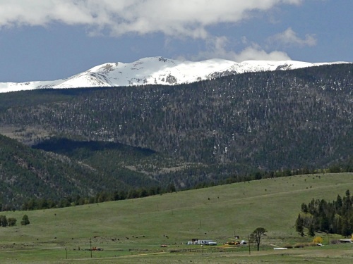 The road enters an
expansive mountain park, which are so
typical in the Rocky Mountains, grassy
plains reaching to the mountains in all
directions. This one has a large reservoir
near its bottom, and another small tourist
town, with a single main shopping street,
Eagles Nest.
The road enters an
expansive mountain park, which are so
typical in the Rocky Mountains, grassy
plains reaching to the mountains in all
directions. This one has a large reservoir
near its bottom, and another small tourist
town, with a single main shopping street,
Eagles Nest.|
|
advertisement |
|
|
advertisement |