| |
| |
Chief Joseph Pass
Maps sometimes get a bit crowded
in this part of the continental divide. Sometimes
"Chief Joseph Pass" does not get a label,
apparently due to lack of space, like for example
on the Idaho and Montana Gazeteer maps. ... and
that in spite of the fact, that it is higher than
the nearby Lost
Trail Pass, which always gets a label. Both
are large paved roads. I am guessing this is due
to the Lewis and Clarke fame of Trail Creek Pass.
Compared to that, Chief Joseph Pass is a
relatively recent construction: Mt43 between the
top of Lost Trail Pass and the town of Wisdom,
Montana. It is on the continental divide and
the Montana - Idaho boundary.
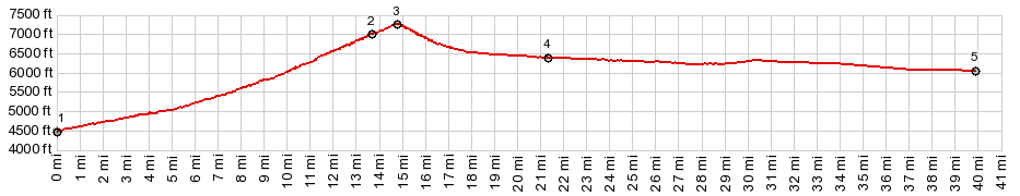
From West. The profile includes the
southern approach from Gibbonsville to Lost Trail Pass.
The northern approach from Sula starts at about
the same elevation, and has roughly the same
length. From the top of Lost Trail Pass
a short straight road leads a little higher to
crest at Chief Joseph Pass. There is a pass sign,
a parking lot and signage for cross country skiing
in the surrounding forest. The Continental Divide
Trail crosses near this shallow summit. It too is
just a forested dirt road through a firewood
cutting area at this point. Heading along the CD
trail north, it is a road to Gibbons Pass. You
can also reach Gibbons Pass by a similar route,
using just a gravel road only. This leads over a
slightly higher summit Lost Trail Rd
s(u). From East. (described downwards) A
straight shallow decent leads down towards the
town "Wisdom". There is little if any visual
evidence, that you are even crossing a mountain
range, other than that the bike seems to roll a
bit easier, while still pedalling it. Signed dirt
road turnoffs allow loops over Gibbons Pass and Big Hole
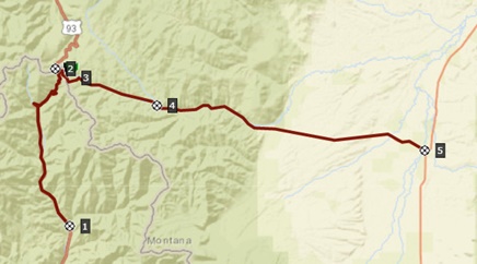
Pass. Dayrides with this point as highest summit: PARTIALLY PAVED / UNPAVED Chief Joseph Pass, Gibbons Pass: Connor
> US93 south > Gibbons Pass > continuing
on FR160 > west on Mt43 > Chief Joseph Pass
> Lost Trail Pass(shp) > back to starting
point: 63 miles with 3800ft of climbing in 5:2
hours (Vetta MC 1.0 m3:10.9.8). ( < FR128
Salmon area s(u) | Lost Trail Rd
s(u) > ) Chief Joseph Pass , Big Hole
Pass , FR945 Foothills Rd s(u) : near
summit of Chief Joseph Pass > Chief Joseph Pass
> Mt43 east > FR 945 Foothills Rd south
<> out and back with double turnaround due
to rain and re-emerging sunshine on Foothills Rd
totalling ~5miles >> Big Hole Pass Rd west
> Big Hole Pass <> short out and back CD
Trail (which is a road here) to a scenic point
>> down west side of Big Hole Pass >
Gibbonsville > US93 north > Lost Trail
Pass(shp) > Mt43 east back to starting point:
61.5miles with 4910ft of climbing in 5:49hrs
(garmin etrex30 m3:20.7.7) |
 Approaches
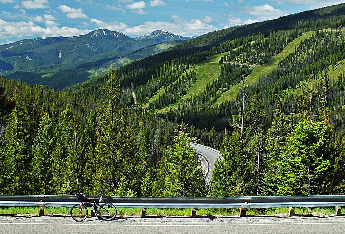
|
|
advertisement |
|
|
advertisement |