| |
| |
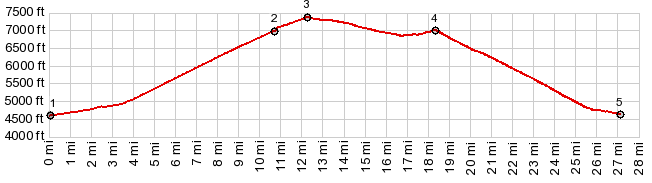
Lost Trail Rd s(u) Lost Trail Rd is the name
given to a dirt road (on some maps),
connecting Lost
Trail Pass with Gibbons Pass.
The point is slightly higher than any of the
named passes in the area, but does not offer
any additional interesting scenic views.
From
North. (described downwards). After a
shallow roll the road meets FR106.3, a short
distance south of the summit of Gibbons Pass.
You could turn right here and follow a quiet
road throughthe forest towards Wisdom. But
the profile turns left and and descends to
Sula. Since I couldn't find any interesting
pictures to take on Lost Trail Rd itself,
all the pictures on this page could equally
belong to the Gibbons
Pass page. But all are taken from
points along the profile on this page.
Dayride with this point as
highest summit:
PARTIALLY PAVED / UNPAVED ( < Chief Joseph Pass | FR5621 Como Lake s(u) > ) Lost Trail Rd s(u) , additional out and back : near summit of Chief Joseph Pass > summit of Lost Trail Pass(shp) > Lost Creek Rd soutn > Lost Creek Rd s(u) > Gibbons Pass(shp) > down north side of Gibbons Pass Rd > Sula <> out and back on Left Fork Rd to turnaround point at first NF campground (on right side of road) >> US93 north > Lost Trail Pass(shp) > back to starting point near summit of Chief Joseph Pass : 55.7miles with 3990ft of climbing in 5:15hrs (garmin etrex30 m3:20.7.8) |
|
|
advertisement |
|
|
advertisement |