| |
| |
FR128 Salmon area s(u)
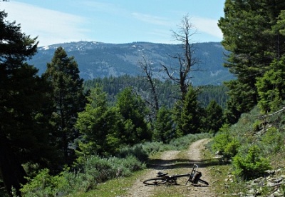
FR23 reaches its first high
point in dense forest. Here the signed
FR128, together with multiple puzzling spur
designated things branch off to the left,
climbing further. This road turns out to
have a few rough moments, surface-wise. If
the light on the first climb was blinding
frontal light, the illuminaton on the
illustrious peaks in the Beaverhead Range
improves with every new clearing the road
reaches. The high point is on this traverse
can only be recognized as such, with help of
a map, after the ride.
Dayride with this point
as highest summit
PARTIALLY PAVED / UNPAVED ( < Williams Creek Summit | Chief Joseph Pass > ) FR128 Salmon area s(u) , addtional out and back : a short distance up FR23 Stormy Peak Rd > up FR123 > FR128 south > FR128 Salmon area s(u) > down FR001 Leesburg Stage Rd > down FR002 > Salmon <> out and back on Lemhi Rd <> Kirtly Creek Rd << turnaround point maybe 3 miles before National Forest boundary >> US93 south > back up FR23 Stormy Peak Rd back to starting point: 40.8miles with 4880ft of climbing in 5:37hrs (garmin etrex30 m3:20.7.3, t20_12) Notes: very hot, but bearable due to a few raindrops accompanying a sandstorm in the afternoon |
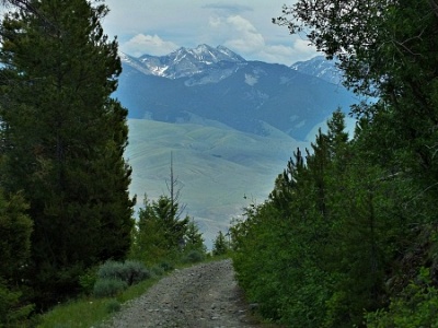 In
the Salmon River Mountains, the scenically
most interesting routes are often not the
ones crossing major ridgelines. Often
those roads are in a dense forest and
surrounded by shallow hills, that obstruct
any far view that might hint at the larger
landscape. Rather, the routes that I have
found to be more interesting, stay closer
to the edge of this range / plateau.
Particularly that part of the edge, that
gives a good vantage point on the
mountains on the other side of the valley.
This is one of those roads. My old maps
don't actually show this route, even
though it is well signed and used. It runs
along below, and parallel to something
called the Ridge Road in the Salmon River
Mtns, between Stormy Peak Rd and the
Leesburg Stage route, going into Salmon
In
the Salmon River Mountains, the scenically
most interesting routes are often not the
ones crossing major ridgelines. Often
those roads are in a dense forest and
surrounded by shallow hills, that obstruct
any far view that might hint at the larger
landscape. Rather, the routes that I have
found to be more interesting, stay closer
to the edge of this range / plateau.
Particularly that part of the edge, that
gives a good vantage point on the
mountains on the other side of the valley.
This is one of those roads. My old maps
don't actually show this route, even
though it is well signed and used. It runs
along below, and parallel to something
called the Ridge Road in the Salmon River
Mtns, between Stormy Peak Rd and the
Leesburg Stage route, going into Salmon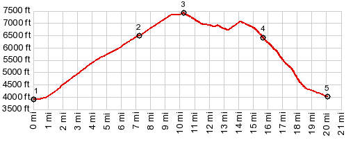
|
|
advertisement |
|
|
advertisement |