| |
| |
Big Sheep Creek Divide /
Medicine Lodge Pass
The GDMBR guidebook calls
this the "Sheep Creek - Cabin Creek Divide".
Historically the name "Medicine Lodge Pass" was
used for this high, historic road crossing of the
Bannack Road. Even if it sounds nicer, none of the
signs in the area use the name "Medicine Lodge".
But signs do use the name for the old Bannack
Road. Today's approach to the pass is only
approximates the historic route.
From North. Meandering Big Sheep Creek has
carved a wide valley floor in places. The valley
floor switches between small, cliff lined narrows
and wide meadows. A few settlements line the road,
alternating with public land, all of it making a
large green sagebrush lawn. The road surface if
fairly heavily graveled and has quite a bit of
washboard. - Not exactly the easiest surface to
ride. At a major junction with roads up Deadman Creek
and Meadow Creek the historic Bannack Road joins.
There is one last small canyon section, and the
road begins a straight, steady climb up a sweeping
inclined plain, reaching up to the foot of the
Beaverhead Range along the continental divide. It
is this large park, ringed by snowcapped mountains
that makes this ride the most impressive for me. The road passes a signed turnoff up Cabin Creek
Rd. This is an alternative way to get to the top.
It is less traveled and has some unsigned turnoffs
- perfectly bikable, but not the path chosen
by the GDMBR. If you use it to make a day loop on
this side, this
becomes the summit. The main road to is a little more circuitous. But
with surroundings like this, circuitous can be
good. The road reaches an intermediate high point,
and then drops a little while heading back south -
and then finally mounts the final attack onto the
summit. Cabin Creek road merges back onto the main
road less than 300ft below the summit. On this
side, it is labeled as a ranch entrance on one
side of the road. The sign with the BLM road
number is on the other side. You could easily
mistake this for a private ranch entrance. The
junction is located just at about the same spot,
where the power line crosses from one side of the
road to the other. The sign at the top of Big Sheep Creek Divide
does not name the pass at all, but commemorates
the old Bannack Road from Corrine to Bannack. From South/East. (also described
upwards). I remember this way up from Clarke
Reservoir as an amazingly straight road,
undulating up and down but not from left to right.
The stark green valley contains some of the most
amazing farm locations I have ever seen. The final
part is surprisingly steep, and thanks to the
gravel I walked a good part of it.
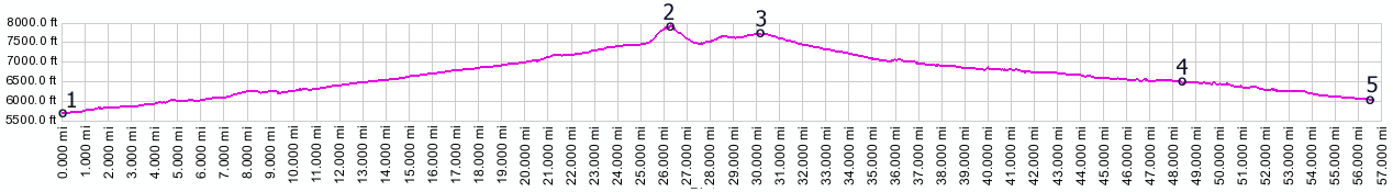
Dayrides PARTIALLY PAVED / UNPAVED ( < Monida Pass | FR147 Ephraim's Grave s(u) > ) Medicine Lodge Pass x2 : Deadwood Gulch campground > up Medicine Lodge Pass Rd > up Cabin Creek Rd > back onto Medicine Lodge Pass Rd <> Medicine Lodge Pass x2 << turnaround point ~380ft below summit >> Medicine Lodge Pass Rd south > Medicine Lodge Pass Rd via Cabin Creek Rd(shp) > back to starting point in Deadwood Gulch campground: 53.6miles with 3700ft of climbing in 6:07hrs (garmin etrex30, m3:20.9.8)
Montana Gold Rush ( < Bannack Pass | Bannock Pass >
): In 1862 gold was found in Bannack. Miners from
all around the west started circling in on the
grasslands of south western Montana. The first
main access route was over the old Medicine Lodge
Pass road. This road goes through the next
drainage west, adjacent to today's I15 and goes
over two passes, the higher one being Badger Pass.
Not everybody came here the direct way. Other
argonauts (as they were called) circled in around
Bannock, paning every promising stream along the
way. Often they searched in already depleted
places on the Salmon and Lemhi Rivers, and then
used Bannock Pass or Lemhi
Pass to get to Bannack. But this mining town
quickly also became the prototypical instant ghost
town. In one year the placers were depleted. After
one year of high life, Bannack has enjoyed an
incredible longevity as an attractive, decaying
ghost town. But there was still more gold to be
discovered in Montana. The action shifted north
and east to Virginia City and Nevada City. Chief Joseph and the Nez Perce Indians (
< Big Hole Pass
| Bannack Pass >) : The old Indian Trail was
used as escape route by Chief Joseph and his Nez
Perce Indians after they escaped from Gibbons at
the Big Hole Battlefield 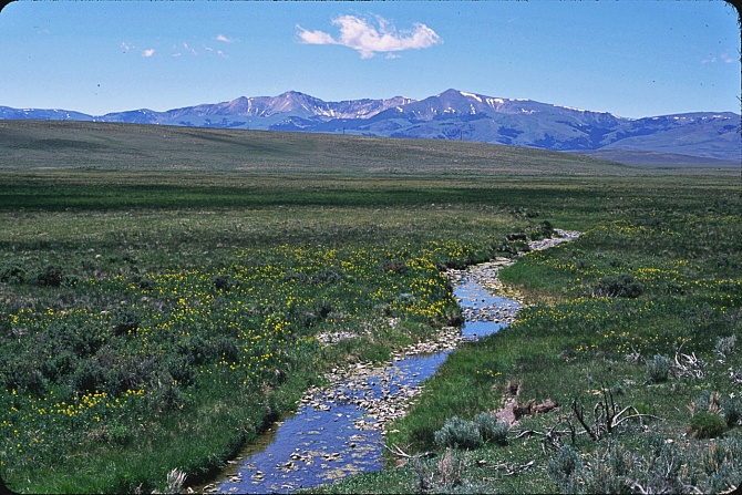 |
 Approaches
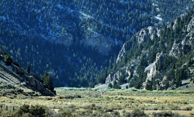 History
|
|
advertisement |
|
|
advertisement |