| |
| |
FR147 Ephraim's Grave s(u) This is one of many summits
in the sage country hills east of the
crest of the Bear River Range. Ephraim is
allegedly the last sighted grizzly bear in
Utah, and the grave is marked on many
maps, including the de Lorme Gazeteer map.
A jeep tourist along the way told me the
bear was 11ft tall, according to legend,
and his skull was displayed on the Utah
State University Campus in Logan. In
reality there seems to be no grave sight
or marker, or memorial plaque of any kind,
anywhere in the vicinity of where the
sight is marked on the map. The
surface of this road is better suited for
a mountain bike than a gravel bike (in my
opinion).
But actually the road rolls
over partially open sage country to another
point that is slightly higher. From
East. (described downwards). That's
it for reasonably far views. A small decent
goes to a T junction. The option to the
right allows rolling downhill in order to
join back to FR147 Blacksmith Fork Canyon.
The option to the left allows for climbing
another summit point and then rolling down
to Logan Canyon.
Dayride with this point
as highest summit
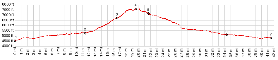
PARTIALLY PAVED / UNPAVED ( < Medicine Lodge Pass/Big Sheep Creek Divide| FR406 Franklin Basin Rd(sh) > ) FR147 Ephraim's Grave s(u) , FR007 Temple Fork Rd via FR56(sh) : a short distance up Right Hand Fork Rd > up Right Hand Fork Rd > up FR147 > FR147 Ephraim's Grave s(u) > FR56 north > FR007 Temple Fork Rd via FR56(sh) > down FR007 Temple Fork Rd > down US89 Logan Canyon > back to starting point on Right Hand Fork Rd : 28.4miles with 3910ft of climbing in 4:08hrs (garmin etrex30 m3:20.9.16) Notes: another short ride for a day, that is much too hot and smoky, and you call this September ??? |
|
|
advertisement |
|
|
advertisement |