| |
| |
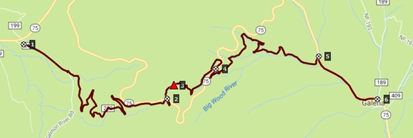
Galena Old Toll Road Trail
s(u)
The Old Galena Toll Road roughly
parallels the modern highway, crossing over it
twice. It also goes a little higher than today's
paved road. Following this option, there is still
a little mandatory pavement, but very little. The
parallel unpaved option exists between the
junction with Salmon River Road and a short
distance above Galena Lodge. One side is an
abandoned road made into a single track trail, the
other an easily bikable dirt road, free of gravel.
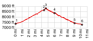
There are a number of dirt roads in the summit
area, so that the summit point on the profile is
slightly different than the summit point on the
Toll Road Trail itself.
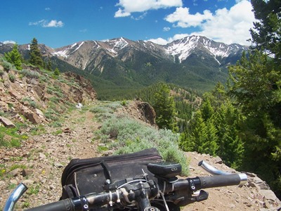
 Approaches While the new highway makes a single large
meander to the north, the old road works the sage
slope with switchbacks. In a way it's less
dangerous, because you don't have to turn your
head back to check for a view. You just wait for
the next switchback. In June there is a much wider
variety of wildflowers to choose from to serve as
foreground for scenery pictures.
Now above the new highway, the dirt road becomes
very steep for a short distance. The option shown
on the profile leads to an unsigned turnoff onto
an abandoned road, immediately behind an
environmental measurement station. It is easy to
miss the turnoff and probably also advisable It is advisable because going straight leads to
the end of an interesting scenic spur at 9000ft.
Walking up an additional 200ft you reach the top
of the hill with a panoramic view, the Sawtooth
Valley with all its ranges on one side, Borah Peak
peaking above the Boulder Mtns on the other. And
below you can make out the roadbed of the Old Toll
Road trail. Also - this view provides confidence,
that the small abandoned trail behind the
measuring station ( at the easily missied turnoff)
actually goes somewhere.
After several hundred ft on this faint trail, it
merges onto the Old Toll Road Trail. This is an
abandoned road that has been reeducated as a
single track trail. It follows close enough to the
road so that you can hear the traffic. It also
contains a few extra switchbacks. Approaching the next highway crossing, the old
road bed has been wiped out completely by the new
roadcut. Getting down to the road involves a short
steep trail. When riding on the road and looking
for this spot, it is very hard to find the first
time. There are no signs, and only the trail on
the lower side of the road is easily visible,
especially from higher up on the highway. Up to this point going has been slow on this
trail, due to rock slides, maybe 20 trees lying
across the road and general abandonment. On the
next part below the highway, things do not get any
better. Not until the trail approaches Galena
Lodge does the going get faster. The last return to the highway involves a
crossing of the here tiny Wood River on a
makeshift bridge of logs and plywood. The trail
ends at a very small dirt turnout on the highway.
The only very small signs at this point point out
ski trails to Galena Lodge and another place. Slideshow 1: Old Galena
Toll Road
Dayride with this point as highest summit: PARTIALLY PAVED / UNPAVED / SINGLE TRACK ( < Trail Creek
Summit | Banner
Summit > ) Galena Old Toll Rd Trail s(u) , Galena Summit
: Chemekatan area on Salmon River Road >
down Salmon River Rd > up FR220 > Galena Old
Toll Rd s(u) <> out and back to end of road
on hill > down Old Toll Rd trail > Galena
Lodge <> short out and back on Gladiator Rd
>> up south side of Galena Summit >
Galena Summit > down north side of Galena
Summit > back to starting point on Salmon River
Rd: 28.2miles with 3320ft of climbing in 4:10hrs
(garmin etre30: m5:17.6.27) The Furtrading Period: Today most visitors arrive at the pass from the south. But as far as the Anglo American world was concerned, it was actually discovered from the north. In 1834 the Hudson Bay Company already had a base as far south as Challis Id. Alexander Ross had explored the Stanley Basin still north of here, and as an afterthought, unwilling to turn back, crossed the pass on Oct 6, 1824 traversing today's highway route approximately between Salmon and Bellevue. The Gold and Silver Rush: It took two years after the first gold and silver was found in the Galena area for the toll road to come into existence. The year was 1881. For a few years a stage service connected Haley with the 800 people of Galena and its four general stores, singular shoe store and several saloons. It took two days to cross to the Sawtooth Valley. Two years after a strong decline in silver prices, in1890, the old town was well on its way to being a ghost town. The next version of the road came in 1919. It is interesting to note that old store at the Galena site has a much longer history than the town itself. It operated between 1924 and 1960. Slideshow2: Pictures taken from the walk-up summit ~200ft above the road summit
|
 Soon the road enters
forest, but windows onto the scenery appear
periodically. For the last part before the first
crossing, the two roads parallel, the old road
slowly catching up in elevation, before one more
switchback leads to the first crossing,
immediately below the summit of the highway.
Soon the road enters
forest, but windows onto the scenery appear
periodically. For the last part before the first
crossing, the two roads parallel, the old road
slowly catching up in elevation, before one more
switchback leads to the first crossing,
immediately below the summit of the highway.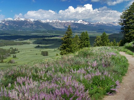
|
|
advertisement |
|
|
advertisement |