| |
|
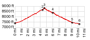
1.(00.0m,7430ft) START-END NORTH: low point immediately past jct Id75 - Salmon River Rd
2.(04.4m,8640ft)Old Toll Rd crosses from new Hihgway from south to north
3.(4.7m,8810ft)TOP
4.(06.0m,8390ft)Old Toll Rd crosses new Highway from north to south
5.(09.0m,7480ft)Old Toll Rd Trail ends on new Highway
6.(10.0m,7350ft)START-END SOUTH: Galena
|