| |
| |
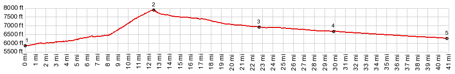
Trail Creek Summit
This seems to be a popular ride in
the Sun Valley area, and the mountain scenery is a
big reason for this. A large part of both
approaches are paved. But a substantial part over
the top is not. Still - I saw several road bikers
on the unpaved section, and more cyclists on the
paved section than in the entire remainder of
Idaho (or so it seemed). This is a classic crossing of a
fault block mountain range, with the steep slope
on the strike side of the range, where the fault
line is, and the gradual dip slope on the east
side.
The ski circus soon ends and so does the bike path. A single long straight away leads to a single long traverse up the strike slope. It aims straight for gap in the range. The pavement lasts for about 2/3 up this traverse. Approaching the summit the road enters the forested gap. The only sign at the top informs that this is the border between Sawtooth and Challis National Forests From North. (also described upwards) The
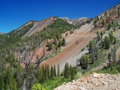
west side of the Lost River Range is one of
largest escarpments in the Rocky Mountains, and
the lower part of this approach makes a perfect
vantage point on this huge fault line mountain
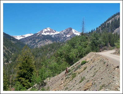
range to the east. Heading for Trail Creek Summit, two approaches
meet at the entrance to the hills on the dip
slope, one making a short cut from the north. The
other named Bartlett Road, forms a short cut to
points south. The profile follows the northern
option. This paved road is peaceful way to enjoy
the majestic Idaho vistas. The pavement lasts till
just before the National Forest boundary.
The road climbs very gradually on this side and
stays at the bottom of wide flat valley with a
wild stream meandering through the sagebrush.
Mountains are isolated small triangular faces,
that appear as backdrop to this sagebrush scene.
The surface is first a hard compressed dirt but
becomes gravel closer to the top. The road seems to head straight for a rock wall
at the end of a shoe carton. But things are not
like they appear, sometimes. Even thought the road
becomes a little steeper and enters forest, it
heads for a wide hidden gap, that surprisingly
opens up the descend at an abrupt fault line. Dayride with this point a highest summit: PARTIALLY PAVED / UNPAVED ( < Galena
Summit | Galena Old
Toll Road Summit ) Trail Creek Summit x2: Ketchum <>
Sun Valley ski area <> Trail Creek Summit
<> turnaround point on other side at jct
with Bartlett Point Rd: 62.2miles with 3620ft of
climbing in 5:37hrs (garmin etrex30 m5:17.6.24)
|

|
|
advertisement |
|
|
advertisement |