| |
| |
Galena Summit
This is one of my favorite roads in
Idaho: scenic - but politely gentle. It crosses
from the Wood River drainage in the south, to the
headwaters of the Salmon and its wild tangled web
of streams, canyons and mountains. But up here
near the top of the pass the headwaters of the
Salmon are very different. It is a cool, peaceful
mountain park. The entire area is part of the
Sawtooth National Recreation area. Cars are few,
but often tow a train of additional recreational
motor vehicles behind them. Everybody seems pretty
relaxed.
Finally Id75 enters the Sawtooth National
Recreation area. Camping opportunities wait at
every dirt road turnoff and around virtually every
corner of the road. The road steadfastly follows
the Big Wood River. In the spring the ridgelines
of the surrounding Boulder Range and Smoky
Mountains are outlined with snow. This makes them
look higher than they really are. The highest
peaks reach between 10200ft and 10700ft. The road
just keeps up with the slope of the swiftly
flowing river until it reaches a level of seven
and a half thousand feet.
From here, the road also increases in grade, and
even makes a curve, that could be called a
switchback. But the radius is so large, that you
don't actually notice that the direction of travel
has reversed, until you see the road just
traveled, immediately below. The curves continue.
Views onto ridges, lined in white in front of the
perfect blue sky from sunrise to sunset -
continue. At the top a dirt road to the east
climbs a little higher ( see Old Galena
Toll Road summit )
In the western US sometimes names appear on maps,
and nothing is there in reality. Here the reverse
seems to be the case. In Smiley Creek there is not
only a restaurant and a sizable collection of
habitats, but also an airport. While I was passing
it was busy with small plains parked next to their
owners' tents - maybe a convention of some sort.
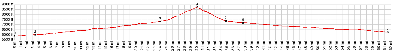
But there is no hint of this on my map. Approaching a point maybe 3/4 of the way up, the
road juts out over the valley and delivers the
best combination of views. The Sawtooth Range
stretches out in a straight line of ragged peaks
towards the north. So that everybody might
appreciate this and return from their vacation
with identical photos, a large parking lot has
been constructed to facilitate stopped
automobiles. From here to the gentle top is just a
short ride with minimal curvature. Approaching the
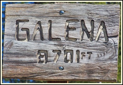
top you can see an older Toll Road version of this
road approach from the west and cross over the
highway to the east. The top has a elevation
marker with a homemade wood carving look to it,
but no names of any sort. 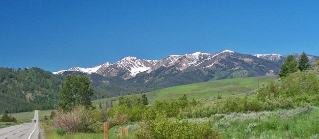 Dayride with this point as highest summit: COMPLETELY PAVED: ( < FR168
Mill Hollow s(u) | Trail Creek
Summit > ) Galena Summit x2 : a short distance up
Lake Creek Rd, north of Ketchum <> down Lake
Creek Rd <> up Id75 <> Galena <>
Galena Summit <> down north side of Id75
<< turaround point a short distance up
Alturas Lake Rd. A Dayride with this point as intermediate
summit is on page: Galena Old
Toll Road Summit
|
 Conditions
change in the place marked on maps as Galena. Once
an mining town, the only thing left today is a
state historic sign, offering information on the
past number of assay offices, buildings and
"hotels". The lodge named Galena has taken its
place, and they apparently rent mountain bikes,
with which one can explore the nearby trails.
Conditions
change in the place marked on maps as Galena. Once
an mining town, the only thing left today is a
state historic sign, offering information on the
past number of assay offices, buildings and
"hotels". The lodge named Galena has taken its
place, and they apparently rent mountain bikes,
with which one can explore the nearby trails.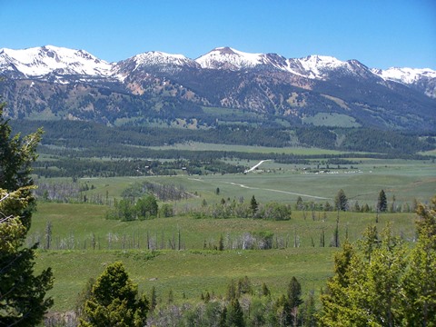 From North. (also
described upwards). The road on this side is
higher and speeds along in straight lines in a big
mountain park. Past the turnoff to Alturas Lake
the mountains on 270 degrees worth of horizon
become more vertical. A whole series of historical
markers detail facts about past mining activity,
gambling houses, hotels and establishments of
related activity. Camps had names like Vienna and
Sawtooth
From North. (also
described upwards). The road on this side is
higher and speeds along in straight lines in a big
mountain park. Past the turnoff to Alturas Lake
the mountains on 270 degrees worth of horizon
become more vertical. A whole series of historical
markers detail facts about past mining activity,
gambling houses, hotels and establishments of
related activity. Camps had names like Vienna and
Sawtooth|
|
advertisement |
|
|
advertisement |