| |
| |
Doublespring Pass Doublespring Pass is one of
two roads that take advantage of wide
shallow gaps in the Lost River Range, in
order to cross between the valleys of the
Little Lost River and the Big Lost River.
The other one is Pass
Creek Summit. Doublespring Pass is
the higher of the two by about 700ft, and
passes near the area of the highest peak
in Idaho, Borah Peak.
At the top of the pass is a
single pair of switchbacks, that mark the
transition between the serene, sweeping
forms of the sagebrush scenery to a needle
forest.
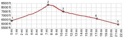
From
North. (described downwards) As long
as the road remains on national forest land,
the surface is a little rougher. It's
a long straight shot towards the dessert
floor. About 800ft below the summit a
labeled turnoff to the right provides the
opportunity to extend the Lost River Range
scenic smorgasbord longer - by crossing Horseheaven
Pass. The profile instead heads
straight for the valley floor.
Dayride with this point
as highest summit:
COMPLETELY UNPAVED ( < Corral Creek Summit | Morgan Creek Summit > ) Doublespring Pass x2, Horseheaven Pass , additional out and back: Earthquake Fault parking lot, a short distance up Doublespring Rd from jct with US93 > up Doublespring Rd > Doublespring Pass > FR117 east > Horseheaven Pass > jct with FR118 <> out and back on FR118 south to a high point overlooking uper Pahsimeroy area > unmarked road along Pahsimeroy River (west side) north > Donkey Hills Rd north > Doublespring Rd south > Doublespring Pass > back to starting point at Earthquake Fault parking lot: 51.3miles with 4890ft of climbing in 5:49hrs (garmin etrex30 m3:20.6.22)(t20_11). Notes: I saw exactly one car, one motorcyle and two road graders along the way. as far as vehicles is concerned. The car belonged to a forest ranger, and the motoricycle to Brad, who told me about the days when you could ride up along the Pahsimeroi River all the way to Leatherman Pass and descend down Dry Creek. It sounds fantatastic. His loop kept going along the east side of the Lost River Range to connect to Pass Creek Rd. - The road graders were at the slightly confusing jct of Donkey Hills Rd and Doublespring Rd. There is also a wide road leading to a ranch here that does not show up on some maps, and the grader operators were instrumental, that I didn't take the wrong route. 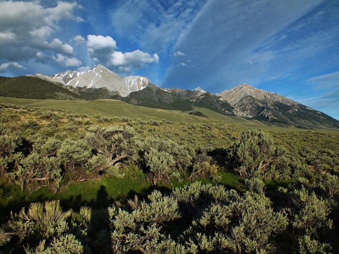 |
|
|
advertisement |
|
|
advertisement |