| |
| |
Corral Creek Summit This road summit does not go
through the major mountain attraction in
this area, the Lost River Range. But it
does have the perfect view onto them. Most
of this road is quite smooth, with one
exception noted below.
Turning in an easterly
direction onto East Fork Rd, another peak is
asking for attention, this time in front. It
turns out to be Hyndman Peak (12009ft). But
it turns out to be up the Wild Horse Basin
Rd. Instead this profile soon takes a left,
but stays on FR135. The road now follows a
medium sized valley that eventually widens
out into a full sized sage plain, ringed by
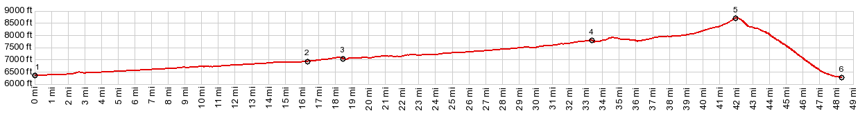
mountains, a park, called Copper Basin. The road keeps on climbing and
eventually the turnoff onto Burma Rd comes
into sight. It is signed. A long shallow
traverse heads back in a northerly
direction, with steadily improving views on
all the mountains delimiting Copper Basin,
including Big Black Dome, which seems to
play the center part in most of my photos on
this stretch. It always looks like the road
is about to crest. But it does not - at
least four times. In the end the road uses
two reasonably tight switchbacks to gain the
top of a vast green sage wave. During this
last stretch the Lost River Range appears
for the first time on the climb. At the top short spurs in both
directions lead to points with even more
encompassing views. Many pictures on this
page are from the eastern point. Slideshow
of Eastern Approach
From
East. (described downwards). This
side is not only steeper, it also is a
little rougher. I would describe it as
medium gravelly, but not rocky. My Klein
Mantra hardly notices these finer
differences. The road is a long travers,
heading north with a permanent view of the
main attraction, the best fault block range
of them all, the Lost River Range. At the
bottom there is even a sign, naming and
pointing up Corral Creek Summit. It is
situated reasonably close to the actual
turnoff (although it can be confusing) and
faces one direction only. The last bottom
1/2 mile of Burma Rd has a hard rock matrix
and is bumpier than any of the rest of the
loop. If coming up this way, this definitely
gives the wrong impression of the route. It
almost seems, that this is supposed to
impart a wrong impression, what the rest of
the road is concerned. 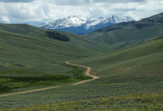
Dayride with this point as highest
summit:
|
|
|
advertisement |
|
|
advertisement |