| |
| |
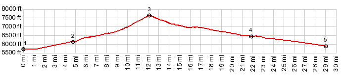
Pass Creek Summit The Lost River Range is
breached by two major gaps. Both contain
good all weather dirt roads, easily
negotiated on a gravel bike. This one is
lower of the two, by about 700ft. The
lower parts on both approaches are a
little more heavily graveled, while the
section over the top is a perfect surface
for any bike with reasonably sturdy tires.
But the major attraction along the way is
the scenery, a wide sage dessert valley on
the east side, and a narrow incised canyon
on the lower west side.
The initial part of the road
goes through a narrow incised canyon. After
that, the valley becomes much wider, but is
still defined by cliffs on each side. Two
switchbacks is all it takes to propel the
road to the sage covered top. From here a road to
Loristica campground climbs higher to
the north.
From
South. (described downwards). Again
there are just two wide curves, before the
road becomes a long bowing alley, aiming for
the north of the outstanding landmark on
this side, Diamond Peak in the Lemhi Range.
This side is visibly much drier and trees
soon become a figment of memory, Given the
right light conditions, they might only
obscure the many fascinating views onto the
Lemhi range. The road eventually splits into
two, one for Patterson and point north in
the Little Lost River Valley, the other for
points south. Both roads taken together as a
loop, still have enough climbing to make
this a shoulder summit.
A dayride with this point
as intermediate summit is on page: Loristica
campground s(u)
|
|
|
advertisement |
|
|
advertisement |