| |
| |
Morgan Creek Summit This summit in the Salmon
River Mountains looks very different from
the canyon scenery, that the river at the
orgin of the name has left below. This is
a fairly generic forest hills ride. A sign
at the top refers to this point as Morgan
Summit, while maps label it Morgan Creek
Summit. No signs on the approaches use
either designation.
Grassy hills lead to another
canyon section. The climb is shallow and
steady. A single triangular mountain top in
the distance still has a minor remnant of
snow above treeline. But it turns out to not
be nowhere near this road. The last part of
Morgan Creek is in the trees and steeper.
There are no views from the top. The road,
branching off the summit and continuing its
climb, also continues to carry the name
Morgan Creek. It is quite a bit rougher and
narrower.
From
North. (described downwards). The
road on this side is named "Panther Creek
Rd". This is a fairly nondescript descent in
shallow forested hills. The surface on this
side is worse. At the jct with Silver Creek
Rd a number of particularly neglected
dwellings line the road, in the middle of
what looks like a slash and burn landscape.
From here the Salmon River is still over 30
miles away. Dayride with this point
as highest summit
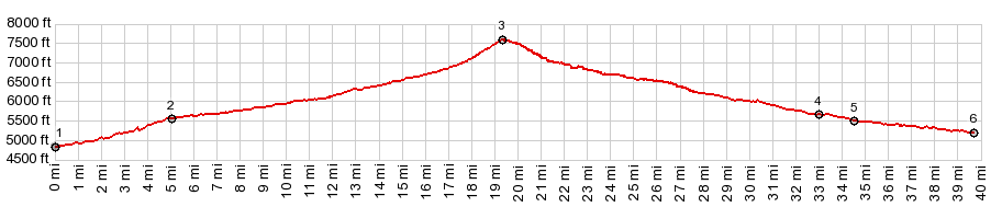
COMPLETELY UNPAVED ( < Doublespring Pass | FR28 Williams Lake Rd s(u) > ) Morgan Summit x2: Morgan Creek Rec area <> up Morgan Creek Rd <> Morgan Creek Summit <>. short separate out and back from the top, a little distance continuing up Morgan Creek Rd towards a signed trailhead <> down Panther Creek Rd << turnaround a short distance past jct with Silver Creek Rd: 47.8miles with 3820ft of climbing in 4:36hrs (garmin etrex30 m3:20.6.24) Notes: very hot on the way out and a touch of rain on the way back - scenically not nearly as exciting as the previous rides along the Lost River Range 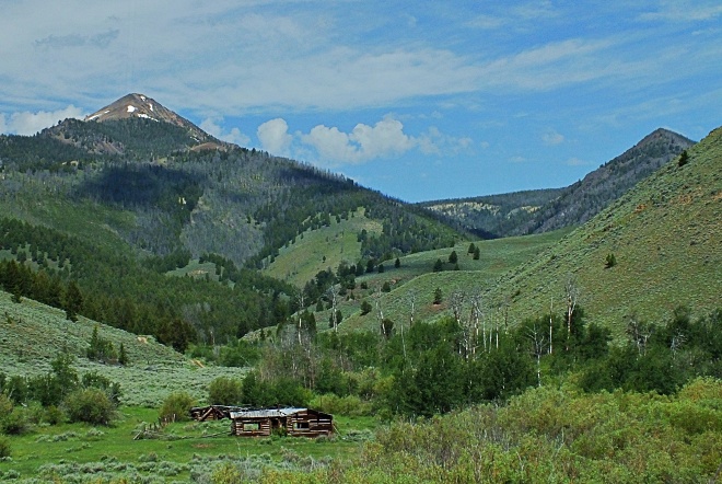 |
|
|
advertisement |
|
|
advertisement |