| |
| |
Timmelsjoch
aka Pso di Rombo Several passes radiate out from
the Meran area. All of them are scenically
magnificent. But two of them have an especially
high cult status with cyclists, first the even
higher 2757m Stilfser
Joch (pso Stelvio), and second this pass.
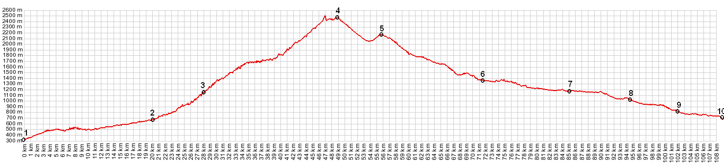
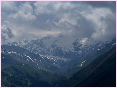
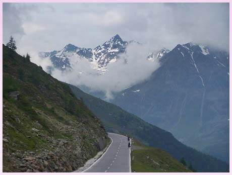
From below it's a series of switchbacks that seem drawn with ruler on a mountain face. Once on top of this series of z's, the road stays long enough above treeline, to take in several viewsheds of sharp glaciated peaks. Several tunnels act as transition points between viewsheds. Also, crossing this pass means a change in environment and climate, Italy to Austria, as well as the gentler mediterranean influence to the colder, wetter Atlantic climate. All this and more makes this a pass with a sort of cult status with cyclists.
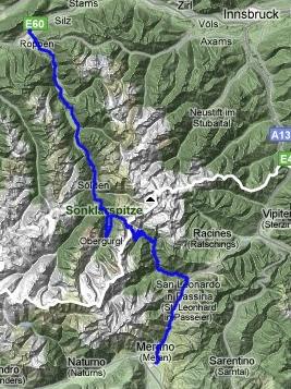
From South. The road starts climbing from
Meran. A bike path leads up the Passaiertal to St
Leonard. It starts at the Meran downtown promenade
area, then crosses the paved road up the same
valley. This totally separate bike path stays
close to the river, while the road sweeps up high
to collect various villages. Once you are on the
bike path it is not exactly easy to rejoin the
road. The bike path is a very pleasant ride,
crossing over the river in narrow, adventurous
bridge constructions, while the main road can have
heavy tourist traffic. The bike path is however
largely unpaved, with one or two graveled
sections, that are actually worthy of a mountain
bike tire.
From St Leonard the road climbs steeply to Mosa. What may at first appear as the pass road ahead is really the val di Plan, with its route up the Meraner Hoehenweg and the Eisjoechle. The pass road switches back and forth to the north (right), gradually dwarfing the rocket ship like church tower of Moso below, while the snow covered peaks above come a bit closer. This first set of switchbacks contains a few short, unlit tunnels. Then a traverse along the valley, gives some time to relax and study the next series of switchbacks ahead, which have an intimidating look, a whole series of z's on a foreshortened cliff face. A small bridge that seems glued to the mountain, with houses apparently suspended next to the cliff below make an interesting motif. These switchbacks seem to take forever and slowly but surely deliver the perfect vantage points on sharp almost-horns like the Seeverspitze (3267m) and the Botzer to the north (3260m). After this long workout, a series of several tunnels begins over the top. The first one is the longest, about half a km. It is lit with lights blinking on the floor. The viewshed changes to the north and takes in a whole new set of mountains. When the pass summit comes into sight, there may be clouds bubbling up from the Austrian side, even if it's been clear so far. This is a significant weather divide. The summit is relatively unspoiled, as passes in the alps go, no hotels, no big parking lots, just a small souvenir shop and a sign saying "good bye Alto Adige" in several languages other than English.
From North. (described downwards) It's
soon apparent that the climate is harsher on this
side. There is more karst topography. A high
valley, comprised of straight geometrical shapes,
descends uniformly. The road still carves through
some snowbanks in the beginning of July. The bike
rolls nicely. It is not so steep that you have to
worry about the brakepads burning out, even on a
fully loaded bike. As a matter of fact, as the
road seems to head straight for another white
triangle in the sky, and the road starts climbing
again substantially. It tops out a second time at
a toll building. This is the town of Hochgurgl,
the highest village in Austria that is inhabited
year round. Motorized vehicles have to pay a toll
here if they want to proceed further down into
Austria. Bicycles are free. Once the road descends
into the Gurgl Valley, it switches back north and
heads for a long gallery style tunnel, that was
visible from the climb on the descent. Then the
road reaches the valley floor, which is now called
the Oetz Valley. Gentle pedaling will speed the
bike through overbuilt ski towns with huge
many-star hotels, lifts wherever the eye may
wander, but thankfully also a few smaller
breakfast pensions, devoid of the standard
solarium, sauna and whatever. Further downvalley
you can pick up the bike path (Oetztal mtbweg). It
is largely unpaved.
|
|||||||||||||||||||||||||||||||||||||||||||||||||||||||||||
 Approaches
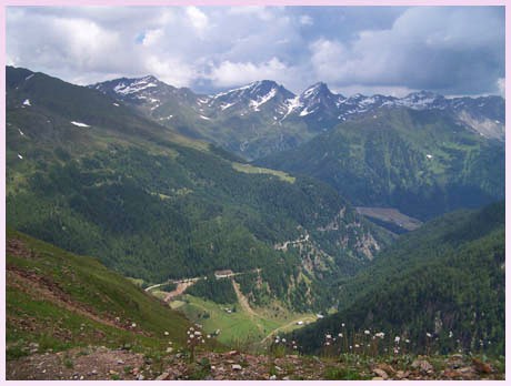
|
|
advertisement |
|
|
advertisement |