|
|||||||||||||||||
|
|
|||||||||||||||||
| |
Hahntennjoch
If coming from the south with all its passes of alpine
splendor, the most obvious quality of the Hahntennjoch is
something that it is not. It has the alpine splendor all
right, but it does not have the ski lifts, restaurants and
general business circus at its summit, that many of the well
known passes have. A ride over the Hahntennjoch is about as
close to nature ( and as far away from civilization ) as a
road cyclist can get in the alps. The road leads over the
Lechtaler Alps, which are not as high as the central ridges
of the alps, but often even more sculpted and precipitous.
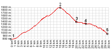
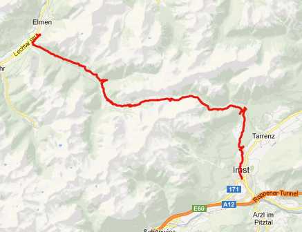
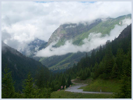
From East. An easy way to find the way up from Imst is to follow signs for Fernpass. This leads around the west side of Imst on a busy road. Leaving town, a steep turnoff to the left leads up Hahntennjoch and away from most of the traffic. The road climbs steeply through the heavily populated outskirts of town and enters a dense forest. Much higher, when the road exits the trees, you suddenly find yourself on the edge of a shelf road with a steep limestone canyon to the right. A silted glacial stream carves its way down under a triangular peak. The climb continues unabated along this traverse, with a much steeper slope below the road than above it. After the road contours the hillside through some sidevalleys, it enters a high valley and crests between two steep ridges. In this alpine meadow below the summit it passes a cow grazing and milking facility of the city Imst. This is the only obvious settlement immediately next to the road since since leaving Imst. The summit is as atypically non-commercialized, just a sign and a very small parking lot for the high alpine trail that leaves from here. Cars don't even have to pay to park here.
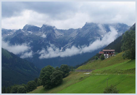
From West. (described downwards). The
road drops steeply in front of high limestone wall. Pfafflar
refers to several alpine huts slightly off the road. The main
road then turns right and descends in snakelike curves to the
turnoff to Boden, which lies nestled between the mountains at a
dead end valley - a very appealing location. The main road
continues at half height between two ragged ridges through
Bschlaps, then continues to roll downvalley through two slightly
lit tunnels ( on the order of 200 meters in length each ),
finally going through a tunnel that is so short it would better
fit the description of a gate. Finally the flat bottomed valley
of the Lech and the churchtower of Elmen come into view. From
here it's only one last unexpected switchback to the bottom.
Here it is possible to pick up the Lech bike trail (Lechtal
Radweg) in either direction, after following the road in either
direction a km or two. This bike path is virtually entirely
paved, a bit longer than the road, fairly well signed (although
a few more signs would help) and much more pleasant riding.
a day on a tour:
back to Cycling Passes in Europe
|
|||||||||||||||||