| |
| |
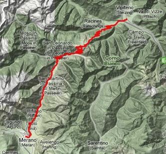
Jaufenpass
aka pso di Monte Giovo With so many pass roads to choose
from when leaving Sterzing (Vipeteno), the
selection is difficult - pleasantly difficult. Why
not cycle to a place, that has just as many
choices as Sterzing ? In that case the route would
go over Jaufenpass, a road reaching above two
thousand meters, that has a fairly high cult
status with cyclists - and at the destination the
choice of routes is at least as hard as at the
departure point, because there are just so darn
many attrative routes to choose from. Jaufenpass
connects the Jaufental (val Giovo) from
Sterzing, with the Passaiertal leading to Sank
Leonard and Meran. Meran and Vipeteno
are veritable hubs on spoked bicycle wheels, with
the passes playing the role of the spokes.
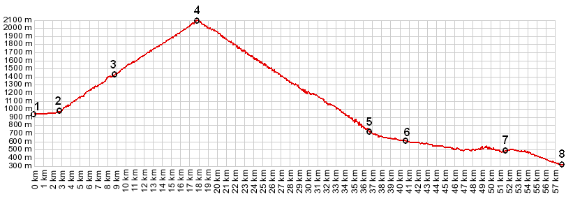
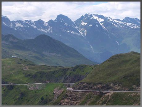
From East. If approaching Sterzing from downvalley Brixen, one can take a bike path all the way to Sterzing. This bike road has many more ups and downs and requires considerably more effort than the regular road. But it has much better views too when approaching Sterzing. A traffic circle south of Sterzing points the way to several passes. One of them is Jaufenpass. The bike path soon ends at another traffic circle, where two valleys branch off. The road starts climbing with switchbacks that are numbered and labeled with altitude. The distance between switchbacks is quite long, so that every turn gets the cyclist one or serveal hundred meters higher. The view is up the Ridnautal. The highest peak there is the Wetterspitze at 2709. The view on the valley keeps improving if the clouds play along, until the road turns south away from the valley and enters a deep forest. About 250m below the summit the road suddenly rises above treeline and traverses along a breadloaf shaped mountain. It passes a Jaufenpass Hotel, still several hundred feet below the summit, and then climbs the pass with several switchbacks. The top has a small restaurant, which is relatively uncommercialized for a pass in the alps. A short walk from the pass, south direction Jaufenspitze improves the view considerably.
From West. (described downwards) The
topographical drop down into the Passaiertal is
much steeper than from the east side, even though
the road is about equally steep. It just requires
a more adventurous road construction. In order to
negotiate the dropoff, the road heads north along
the treeless slope, bordered by a low stone wall,
and supported by a much higher wall at the drop
off. It then switches back in a long traverse
direction Jaufenspitze. It enters forest, then
switches back again. Even after thousands of feet
of descent the church tower down in the
Passaiertal hardly seems to have come much
closer. The highest settlements above Sankt
Leonard appear glued to the hillside, long before
the road enters the deep slit, where the village
itself lies. As these houses disappear from the
upper field of view, obscured by the sheer slope
of the mountain, the bike rolls into Sankt
Leonard. The inner town core spans itself at least
a hundred feet of elevation. The tourist info
center is in the lower part, and the few
economical penisons are in the upper part of town,
so it may be wise to spare a little energy till
the end. The elevation profile continues further
to Meran.
|
 Approaches
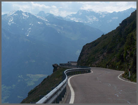
|
|
advertisement |
|
|
advertisement |