| |
| |
Col de Tentes(ow)
(also includes Cirque de Troumouse(ow)) This high, wild and windy one-way
paved summit is near - but not on the France -
Spain border. Numerous people mentioned to me that
fact that it was on their "bucket list", ie a list
of things they feel they have to do. Surprisingly
many people like to have to do things. So there
can be a lot of traffic, bicycle and otherwise. On
one side the popularity with cyclists is
surprising, because neither summit has ever been
on a Tour de France stage, and they never will be.
The reason is, that they are too environmentally
sensitive. One is located in a National Park, the
other in a designated World Heritage Site. On the
other side you can understand the popularity.
Philosophers and writers remarked about the beauty
of these places already generations ago. Victor
Hugo called the Cirque de Gavarnie a "colloseum of
nature" and Flaubert considered it the most
spectacular thing he has ever seen (just to drop a
few famous names). During the time I was here, it
was very cold and windy. Almost all the
motorized traffic remained in the last "village"
below, Gavarnie. Above that there were still some
traffic, mostly cyclists, sheep herders and hiking
/ mountaineering traffic. But I'm told during
vacation season in August, Gavernie is
"overcrowded as hell", and every Frenchman has to
visit here at least one time, preferably on the
back of a donkey. But the most important thing about
this pass is its superlative scenic spectacularity
factor - very high, and when it's cold and windy,
you mostly have the place to yourself. The profile
goes a little beyond the pass itself, direction
Port de Bucharo, as far as the pavement lasts.
From there a trail leads down to a paved road in
Spain.
As the road leaves Luz-St-Saveur, it enters the
next canyon, far above the last incised V. The
bridge over to les-Baines-de-St-Saveur has made
many cyclists and drivers stop alike, in order to
take another look. I included a photo. It was
commissioned by Napoleon. Above the village Gedre the road forks into 3
options. Gavarnie gets the most traffic. From this
junction, the churchtower in Gedre appears from a
birds eye perspective. Here the road finds a new,
higher hanging V-shaped canyon, and crawls along
its bottom on a thick carpet of green. There is very little that prepares the visitor of
what there is to come, starting in Gavarnie. Until
then uou only get a glimpse of the peaks a few
times along the approach.In other countries, that
shall remain unnamed, they would put up cheezy
billboards and construct go cart racetracks next
to the road. Gavarnie itself is a spectacle
in itself with its shops and restaurants and even
a few nick-nack shops. It is a tourist circus, but
somehow more tasteful than what you might expect
elsewhere. To me it looks a little bit like a
campus of hotels. All the businesses and other man
made distractions line the route into the cirque.
Along the way you catch glimpses of a most amazing
water fall at the end of the cirque. The way the
town is set up reminds me of the setup in nearby
Lourdes, with a central highly adorned and well
designed promenade, leading to a central
attraction, weather it be the cathedral in Lourdes
or the waterfall at the head of the cirque. Here
the altar is made by nature - also a form of God
in the many eyes
I am amazed by how many cyclists I see up here,
working very earnestly to get up into, what today
seems like a pretty cold and incredibly windy,
hostile environment. But then again - I am here
too. This last part of the climb consists of
3000ft of climbing on switchbacks between tundra,
skilifts, freely grazing sheep, and a maze of
power lines. These take advantage of the other
pass up here: the Port de Bucharo to cross over
into Spain. The top of Col de Tentes is a fairly
large parking lot. Only 2 cars are there on the
day of my visit. Pic de Tente is not much higher
than the pass. A well troten trail leads up to
what promises to be a panoramic view - panoramic
but contained in France. Col de Tente only crosses
a perpendicular rib of the main ridge, forming the
France - Spain boundary. The pass on the main ridge is Port de Bucharo,
even if it is just a few meters lower. What looks
like an old highway leads up to it. The first part
is well paved and included in the profile. After
that it is easier to walk the route because of
extensive rockfalls. But it is an wide, well
engineered road bed all the way to the top of the
Port. I walk the rest of the way to the v shaped gap in
the monumental ridge. It is extremely windy. As I
hurry between shelters from the wind to steel a
glimpse into Spain, I see two hikers coming the
other way, equally anxious to find out what France
looks like from this vantage point. We wave hello,
but it is too windy to try to communicate. After
taking pictures with partially numb fingers we
hurry back to our respective countries of origin
(and hope the pictures came out okay). I have
always been wondering, if it was feasible to ride
and/or walk a mountain bike down the Spanish side
to the road in the Monte Perdido National Park. I
suspect it is possible, but not during weather
like this. Slideshow of Col de Tentes and Port du
Bucharo
 Sidetrips: Sidetrips:Cirque de Troumouse(ow) This route branches off the first profile fairly early. It is really a day ride in itself, not something to quickly fit in before Col de Tentes. You notice one big difference right after the signed turnoff above Gerde with its great view of the valley and church below. There is hardly any traffic on this road. The surface is a little rougher too. But you don't notice that until you build up some speed on the way down. The road stays at the bottom of the valley and the mountains are only visible framed by a high green V. But that is a temporary condition. the goal of another possible sidetrip from the cirque now becomes visible, together with the turnoff: to it: a damn, the barrage de Gloriettes. I have skipped it sofar. Another place along the road, marked on the map, Heas - is just a house that is some sort of vacation base. It did not exhibit any signs of life when I was there. But it does mark the transition of where the road goes above treeline and starts its first set of switchbacks. It becomes clear that the road is not going to try to get into that narrow gorge in front of the white wall, but instead work itself up the tundra slope to the right. This first set of switchbacks ends on a small plateau and then goes down a short hill to another inn of sorts. From here another set of switchbacks climbs the knoll that sits at the base of the cirque. There is a large dirt parking lot here, and several trails take off to explore the width of this bowl, including a small knoll with a Maria statue on top. None of these trails show signs of climbing out of this 3000 meter high amphiteater of rock and ice. It is an amazing place.
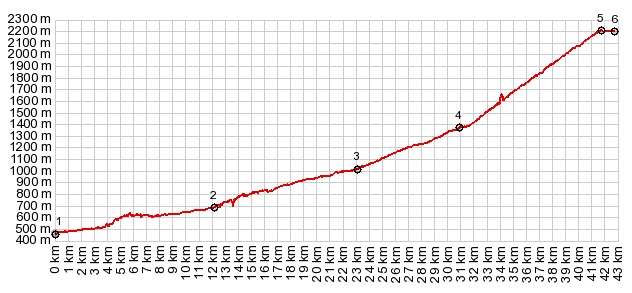
Dayride with at least one of the points on this page as highest one-way summit, and no two way summits ( < Lac d"Aubert/d'Aumart(ow) | Hautacam(ow) > ) Col de Tentes(ow) : Pain de Sucre campground below Gavarnie > Col de Tente(ow) << Gavarnie > closed loop with out and back through Gavarnie towards cirque >> back to starting point below Gavarnie <> separate out and back down the road with turnaround point Gedre: 29.0miles with 4703ft of climbing in 4:06hrs Notes: day also included a walk to Porte de Bucharo and a hike up Pic de Tentes(2322m) h+b: max-min=7621-3337=4284, 30.5miles with 5584ft of climbing in 4:54hrs h only: 1.5miles with 881ft of climbing in 48min ( < Col des Borderes | Col de Arnosteguy > ) Cirque de Troumouse(ow) : Boo-Silhen <> Luz-St-Saveur <> Gerdre <> Heas <> Cirque de Troumouse(ow) : 61.1miles with 6360ft of climbing in 6:00hrs Notes: day also included a walk to the short unnamed knoll, a small high point in the amphitheater of the cirque h+b: maxelev-minelev = 6960ft-1430ft=5530ft; 63.1miles with ft of 6661ft of climbing in 6:56hrs Slideshow of Cirque de Troumouse summit
|
 But actually the profile bypasses
the town Gavarnie and its views of the cirque
completely and heads for the pass above it.
Chances are good that on the way down there is
still plenty of time to check it out. The road now
starts to climb above treeline. It ascends in
switchbacks between confining vertical walls,
topped above by sandwiches of white. The top of
the view is often indistinct - merging into
clouds. Signs make it clear that the road enters a
National Park. Other than signs informing of what
is not allowed here (camping and biking on trails
are amongst them), there are no other costs or
formalities to be completed.
But actually the profile bypasses
the town Gavarnie and its views of the cirque
completely and heads for the pass above it.
Chances are good that on the way down there is
still plenty of time to check it out. The road now
starts to climb above treeline. It ascends in
switchbacks between confining vertical walls,
topped above by sandwiches of white. The top of
the view is often indistinct - merging into
clouds. Signs make it clear that the road enters a
National Park. Other than signs informing of what
is not allowed here (camping and biking on trails
are amongst them), there are no other costs or
formalities to be completed.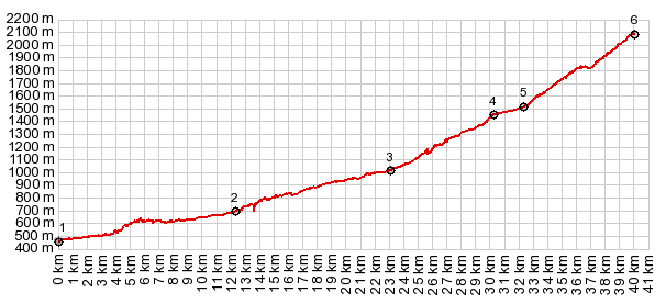
|
|
advertisement |
|
|
advertisement |