| |
| |
Lac d'Aubert /
d'Aumart(ow)
also includes Barrage de Cap de Long[ow] This is a remarkably long, high and
(for Europe) isolated climb into a high mountain
area of damed lakes. The road forks for the last
300 meters of climbing, so that there are two
one-way summits, that lend themselves to being
cycled in the same day ride. The two one-way
summit points are at roughly the same elevation,
but have a very different character. I packed
along hiking shoes on this ride, and I am glad I
did.
Now on much rougher pavement and with practically
no traffic, the route leads up the bottom of a
rugged, incised V shaped canyon, in thick forest.
When the switchbacks start, they follow each other
very quickly. It is not like a waltz, it is like
the twist. Still - the road never has a chance to
climb out of the narrow valley. At the jct with
the road to the other one-way summit point at Cap
de Long (see below), a small downhill leads to a
narrow crossing on a small lake, flanked by a
restaurant. The last act of this climbing play starts with a
traverse, still in thick forest. The road climbs
above the lake and reaches a saddle. During this
section you get a good view of the other option,
the ride to Cap de Long. This last part to Lac
Aubert is in a designated "wild(erness) area",
where cars are not allowed to park, as well as
other restrictions exist for dog and man alike.
The two lakes at the summit are just slightly
above treeline, and also managed with dams,
although these are much smaller than the one on
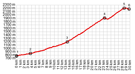
Cap de Long. The summit section is relatively
short. Yet most of the pictures are taken there.
The lakes are located in a shallow high valley,
and they seem like an invitation for a comparison
with other alpine environments around the world.
There is very little if anything in the form of
man made structures, that would exhibit a local
regional character, The mountains. lining
the valleys are wild and vertical. From this side
most look utterly unclimbable, but many north
faces do. From the immediate environment it is
difficult to guess the relative high elevation of
the lakes where the road ends. Here a well used
trail with two destination options invites for a
hike, leaving from a large parking lot.
Barrage de Lac de Cap de Long. The other
out and back climb from the fork has a completely
different character. While the road to Lac Aubert
has a wild scenic beauty to it, this side is more
industrial in character. From the final traverse
to Lac Aubert a thousand feet below the high
point, you can see a wall, gluing shut a high
valley above, at its exit. The dam seems to
connect two mountain sides, rather than just a
block off a narrow exit of valley. After a short
level area a final set of switchbacks leads
through an assemblage of ramps, viewing- and
support structures. Much of the area along the
road has transformed into platforms of some sort.
What uses they all have or had is impossible to
speculate. Many of these structures give the
impression of a complex of industrial ruins. At the top a curious small restaurant has signs
offering guide services and coffee. It is possible
to bike across the dam to the other side. The map
shows a hiking trail leaving from there, but all I
saw was vertical rocks. The other road from the
restaurant/bar follows the west side of the
reservoir. It is repeatedly blocked by large
rockfalls, that take considerable time to cross. I
never did get across all of them.
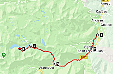
Dayride with no two way summits and this point as highest one way summit: ( < Col d'Azet | Col des Tentes(ow) > ) Lac d'Aubert/d'Aumart(ow) , Barrage de Cap de Long(ow) : Vielle Aure > St Lary-Soulan > la pont du Moudang > to end of road at Barrage de Cap de Long << back down same way >> to end of road at Lac d'Aubert/ d'Aumart(ow) << back down to la pont du Moudang > back to starting point in Vielle Aure: 44.5miles with 6223ft of climbing in 5:23hrs (garmn etrex 30 r5:19.6.4) Notes: day also contained a hike from Lac d'Aubert to a pass north of there h+b: max-min=8255ft-2556ft=5699ft, 48.6miles with 7480ft of climbing in 7:27hrs h only: max-min=8251-7084=1203ft, 3.1miles with 1243ft of climbing in 2:24hrs |
 Addtitional one way summits on
this route:
Addtitional one way summits on
this route: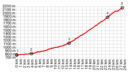
|
|
advertisement |
|
|
advertisement |