| |
| |
Col del Roque Jalere
This pass crosses a high and dry
plateau, north of the Massif de Canigou, which is
part of the main ridge of the Pyrenees. In this
area, this is the pass with the most far reaching
views, including other passes, that are quite a
bit higher.
This pass is located at the highest point, and it
marks the exact spot where the road turns away
from the Massif de Canigou. There is a short grown
over traill at the top, that climbs one of these
wind swept bread loaves a little higher. Some of
the pictures in the slide show are taken from that
trail.
From South. (described
downwards) After a very short ride through forest,
the viewshed opens up in an equally grand and
sweeping way direction north. The road contours
around a gentle amphitheater of sweeping high
grass. Only slowly does the transmission facilty
on the top of the mountain actually move into the
upper field of vision. The village Campoussy is an
alternate to the signed main route. It is not
really much longer, but the more interesting
route. After a tiny climb, more gentle descend leads to
the old village, Sournia, and a further descend
leads to a low point at a bridge crossing a creek.
A hundred yards away remnants of an ancient stone
arch bridge still look functional for people to
cross
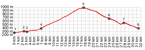
Dayride with this point as highest summit: COMPELTELY PAVED ( < Col de Jau | Plateau de Salinas s(u) > ) Col de Roque Jalere , Col des Auzines x2: Rodes > Eus > Col de Roque Jalere > Sournia > Col des Auzines <> out and back to just past Trevillach ~95m below Col des Auzines >> Col des Auzines > Talerach > Marcevol > back to starting point in Vinca: 41.9m with 4138ft of climbing in 4:432hrs (garmin etrex30 r5:11.5.10) Notes: the short and slow ride after a long and not so slow ride. The local "baquette goats" (picture below on right) managed to nab one of my baguettes, sticking out of the saddle bags. Luckily I could save the second loaf. A Dayride with this point as intermediate summit is on page: Col d'Aussieres 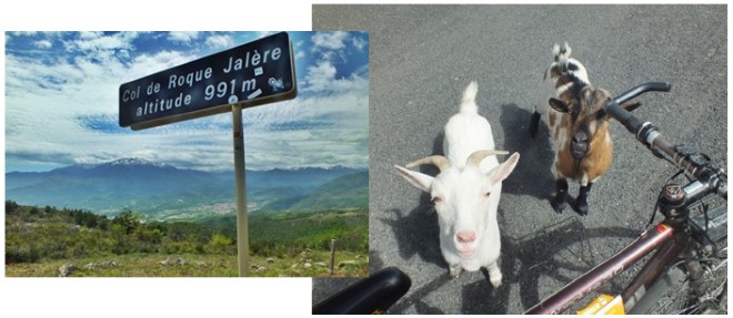 |
|
|
advertisement |
|
|
advertisement |