| |
| |
Col de Jau
When studying a map of the area
north of the Canigou Massif and its vast sweeping
mesas, this is the pass that first stood out to
me. For European standards this is a road with
long distances between towns and supply points.
The old towns along the way are also the most
interesting feature of this ride.
A choice between two pass roads needs to be made
north of Rhodes: Col du Jau or Col du Roques
Jalere. If the weather is currently good for
far views, but might deteriorate in the afternoon,
my choice would be Roques Jalere. Col du Jau too has its fascinating points, but
far views are not one of them. The last good view
of the Massif du Canigou is at the junction with
the road to Col du Roques Jalere. What's
interesting about Col du Jau are the towns along
the way. First comes a luxury therme (spa) hidden
in a small amphiteater in the landscape. And later
comes the most memorable town vista along the way:
Moussat. You'll know it when you see it.
From South. (described downwards) For
European standards this descent has a very
isolated feel to it.There is really only one town
visible from the road, sitting on a hill, a km or
two away. The next place with people is Alat.
Between here and there: a beautiful curving
descend into gentle plateau country. Before Axat
one more surprise: a short slot like canyon: the
Gorge de St Georges.
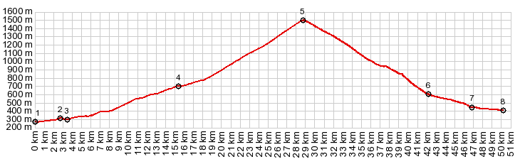
Dayride with this point as the highest summit: COMPLETELY PAVED: ( < Col de Palomere | Col de Roque Jalere > ) Col de Jau , Col d'Aussieres s(u) , Col del Roque Jalere , Col du Camperie: Rodes > Eus > Moltig-les-Bains > Campome > Mosset > Col de Jau > Axat > Col du Camperie (514m) > Salvecines > Gincla > Montfort sur Bulzane > Col d'Aussieres s(u) > Rabouillet > Sournia > Col del Roque Jalere > Eus > back to starting point in Rodes :82.1m with 8799ft of climbing in 7:59hrs (garmin etrex30 r5:19.5.9) Notes: Col cu Camperie is a signed pass in the forest on a small hill History Cycling - Tour de France: This pass was three times part of the tour: in 1976, 1993 and 2001. This is one pass where the stages containing it, were all won by French cyclists. |
 The road seems to change
width several times. But it stays in a low ravine
the entire way. Approaching the top the plateau
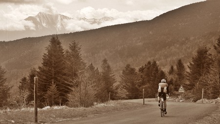
the road enters into forest. From the top you can
make out a far ridge of the Massif du Canigou, cut
of by a shoulder of trees. This seems to be a
popular gathering spot for cyclists. I talked to
several about the most diverse subjects.
The road seems to change
width several times. But it stays in a low ravine
the entire way. Approaching the top the plateau
the road enters into forest. From the top you can
make out a far ridge of the Massif du Canigou, cut
of by a shoulder of trees. This seems to be a
popular gathering spot for cyclists. I talked to
several about the most diverse subjects.|
|
advertisement |
|
|
advertisement |