| |
| |
Plateau de Salinas s(u)
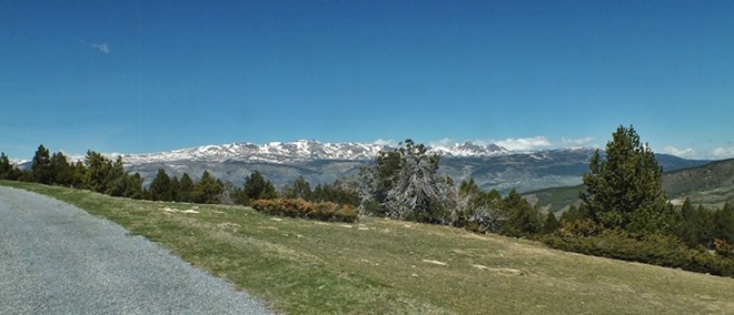
This road leads high into the
sweeping "palouse" above Puigcerda. Palouse
translates to "lawn", but I think "tundra" is the
better fitting definition here. One approach to
the plateau is paved and it also includes the Col
de Pradeilles. From there a narrow paved spur
leads another 400m higher onto a set of rounded
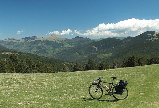
mountains, covered by a single extensive.sprawling
green carpet From here the profile finds a
mountain bike route down the other side. There are
several possibilities for this. The one shown, I
did on my touring bike, electing to hike a good
part of it. With a mountain bike - no problem.
The views keep improving, now taking in also a
rugged ridge to the west - when finally the bumpy
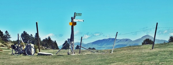
little road enters the forest. A junction marks
the beginning of a loop from here, whose high
point is Col de Pradeillles. The sign indicates
that the recommended direction for this loop is to
take a right here. The profile follows this
recommendations, and the road descends just ever
so slightly. But the disappointment does not last
long, as the road resumes climbing again with
renewed vigor. This time it climbs in the forest. After a good workout the road reaches Col de
Pradeilles. This is the opposite of Stelvio Pass,
or any of the other famous roads with a circus of
businesses at the top. There is nobody here trying
to sell you cycling jerseys. There is no hotel, no
bar, not even a bank. A rustic ever so carefully
placed bench marks the high spot, and invites for
a picnic lunch with a breath taking view. The pass
sign itself is on the other side of the road,
nailed to a tree. The pass is located is a meadow
just below tree line. Just a few meters after the pass, a right turn
off the loop road gets you onto a paved out and
back to the Pla de Salinas Summit. The road climbs
above treeline and a few wisely placed turns help
climb onto a gentle tundra slope. The trees just
at treeline are extremely contorted and
imaginatively shaped, as is often the case. The paved road ends at a dirt parking lot just at
the Spanish border, which is entirely deserted
when I arrive here.
From South. (described
downwards) An unpaved track continues on the
gentle sweeping plateau or mountain (I can't
decide which one it is) to the north. The profile
follows this for about a 100 meters, then crosses
a fence (the French - Spanish border) and picks up
faint vehicle tracks heading in a southerly
direction. A view of more heavily used tracks
below help make the choice of following these
barely visible tracks, easier. But - bad news: the descend becomes very rocky
and steep, very much an ATV track, but only for a
short time. Climbing this short section would take
a lot of energy. Then the track again is easily
ridable on the "palouse", reaching the Col de
Creiu de Meians. It is marked with a cross, and a
plethora of signs pointing in 3 general
directions. The option that would seem to promise a fast
descent to the paved road in the valley, instead
switches back to the west and contours along above
the road for a long distance. My choice finally
(after trying the other two) was, was to head
direction Puigcerda, that is back north. On a
mountain bike this soon becomes a quickly ridable
dirt road. But it still contains a few up and
downs along the traverse direction north. The last
several miles are on a wide dirt road, the likes
of which are common in my home, Colorado - about 3
times as wide as the paved cols through old
villages that I had been riding during the past
days. - What a change. The road meets pavement
during the final descent to Queixans, a Catalonian
village on the Spanish side. The houses have a
completely different look than where I started
today's ride.
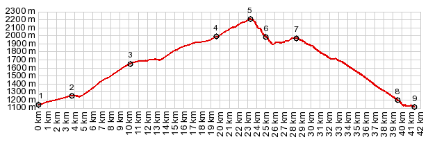
Dayride with this point as highest summit: PARTIALLY PAVED / UNPAVED ( < Col de Roque Jalere | Col de Puymorens > ) Pla de Salinas s(u) , Col de la Creu de Means : Latour de Carol > Bourg Madame > Osseja > Col de Pradeilles(shp) > Pla de Salinas s(u) > Col de la Creu de Meians (shp,2000m) <> out and back towards Freser with turaround point ~90m below Col de Creu de Meians > Col Marcer (shp,1946m) > Queixans > Puigcerda > back to starting point in Latour de Carol: 43.2m with 5350ft of climbing in 6:06hrs (garmin etrex30 r5:19.5.12) Notes: Col Marcer doesn't have a possible 500ft of elevation gain on this side - turnaround point below Col de Creu de Means because it was getting too late to go all the way down north side - day also include a hike towards the mountains to the east from highest point of ride. |
|
|
advertisement |
|
|
advertisement |