| |
| |
Col de Praletang
This plateau, bordered on all sides
by more or less steep limestone cliffs, is like an
island with forest on top. Between the Vercors and
the Drome regions are several "islands" like that.
On the north and south this plateau is bordered by
the valley of the Isere, stretching north to
Grenoble. In the south it s bordered by the Gorge
de la Bourne. At least 2 named passes on small,
mostly paved roads are located in this plateau. I
was going for the higher one "Col de Mont Noir",
but new snow on the top convinced me to cross this
one instead.
The road becomes ever narrower, and before
reaching the village Presles, a right turn onto a
paved forest road marks the spot, where the
absolute minimum of road width for this journey
begins. Now on the plateau, the road climbs not
quite as steeply but steadily ever onwards through
the forest. Past a farm and a junction, leading to
Col du Mont Noir amongst other destinations, the
road leads to a first clearing (and with that a
good view) since quite a workout ago. In the view
below, the limestone entrance to the Gorge de la
Bourne has taken its place in the surrounding
landscape of cliffs and forests. From here that
spectacular gorge it is just a breech in a lip of
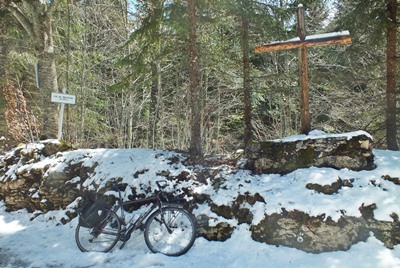
a limestone cliff. Approaching the summit, the forest seems to
become ever thicker. The road passes a map of the
area (which can be very confusing), curves around,
past a turnoff for a cave that can be explored,
and finally one more curve leads to a summit. It
is marked with a rudimentary wood cross and a pass
sign.
From East. (described
downwards) After rolling through the trees, a
great view of the main part of the Vercors range
behind limestone cliffs of the Gorge de la Bourne
appears at the site of an abandoned inn. I know of the practice of labeling single family
dwellings with place names on the map from Wyoming
and other sparsely populated US states. But here
in France ? Yes - here in France. On the way
down, the two single most spectacular vantage
points onto Rencurrel and the vertical scenery
below are occupied by single farm dwellings, and
the dwellings or "villages"; have a name, complete
with signs as you enter and leave only a few dozen
meters apart - even if I forgot what the names
are, and they are not marked on my openstreetview
map. In Rencurrel the pavement widens and the profile
goes back down to where it meets itself on the
other side
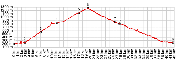
Dayride with this point as intermediate summit: ( < Font d'Urle s(u) | Col de Bataille > ) Col de Praletang , St Julien en Vercors s(u) : Pont en Royans > Col de Toute Aures(shp) > Col de Praletang > Rencurrel > D531 east > D103 west > St Julien en Vercors s(u) > St Martin en Vercors > D518 west > Eulalie > back to starting point in Pont en Royans: 39.3m with 4779ft of climbing in 4:25hrs (garmin etrex30 r5:19.4.26. Notes: In this ride on the Friday after easter fresh snow covered the upper 100 meters of the climb |
 Approaches
|
|
advertisement |
|
|
advertisement |