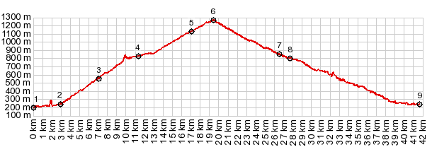
1.(00.0km,0190m)START-END WEST:low point
next to river La Bourne, Pont en Royans
2.(02.9km,0240m)profile leaves Gorge de la Bourne and
climbs to Col de Toutes Aures
3.(07.1km,0560m)Col de Toutes Aures
4.(11.3km,0830m)profile turns right before reaching
Presles
5.(17.0km,1130m)profile stays right at this junction.
Left goes to Col du Mont Noir
6.(19.5km,1270m)TOP: Col de Prelatang
7.(26.5km,0850m)profile turns right at junction with
road coming down from Col de Romeyere
8.(27.8km,0810m)Rencurrel
9.(41.6km,0240m)START-END EAST:same as point 2 in Gorge
de la Bourne