| |
| |
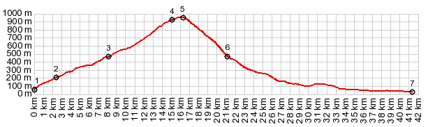
Poklon s(u) Istria has one high ridge,
standing high over the rest of the
peninsula. It sits directly on its eastern
shore and overlooks the Mediterranean Sea
and the Kwarner Bay. This road crosses
this high green ridge, and an out-and-back
summit, leads to the highest topological
point in all of Istria. On my ride in mid
October there was an amazing temperature
difference between the top and the sea
(much much colder on top).
Signs give the impression that
the turnoff to the one way Vojok summit is
here. However it is a little further up, but
still before the high point of the main
road. The Poklon summit is in the trees
without views or signs, or occasion or
reason to stop.
(pronounced Voiok) Many people
walk up this road, although there is an
occasional car on it too. Given all the
other narrow, yet driven paved roads around
here, this one is actually very wide. The
road is a pleasant climb. But it stays in
the trees all the way to the top. Although
approaching the top, it becomes slightly
shelf-like and no trees obscure the view to
Rijeka and its big bay, really the same view
as near the beginning, but now at eyelevel
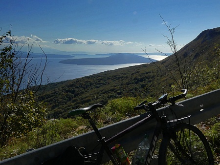
with the highest mountains behind the city. Not until the road ends, and
the bike is pushed or ridden up a short
walkway along the ridge to an old defensive
tower, does the view over the Istrian
peninsula open up. During my visit, It was a
perfectly clear day and the Dolomites to the
north were a distinct different shade of
blue and white than the clouds and the sky.
Next to the old defensive stone tower, today
there is also an adjacent transmission
tower.
Slideshow of the out and
back summit
Dayride with this point
as highest summit:
COMPLETELY PAVED: ( < 58064 Moscenice - Brsec s(u) | jct 5047-5048 Veprinac s(u) > ) Poklon s(u) , D66 Piomin s(u) , additional out and back summit: Icici > Opatija with wrong way detours > Pobri > Mihotici > Zatka > Veprinac <> Vojac(ow) > Poklon s(u) > D500 south > Voclici > D66 east > D66 Piomin s(u) > D66 north > Brsec > Moscenicka Draga > Kraj > Medveja > Lovran > back to starting point in Icici: 62.5miles with 6560ft of climbing in 6:27hrs (garmin etrex30 r5:21.10.14) Notes: I meant to go up the other serpentine lower approach, directly from Icici, but didn't find the turnoff, not realizing that I was actually camped on it (Opatija Autocamp). On the out and back climb to Vojok(ow), there was a nice mix of cyclists, representing almost every current branch that the sport has taken: several mountain bikers, several racing bikers, 1 electro biker, and one girl carrying up the bike on a hiking trail around her shoulders all the way from Matulji (1 touring type bike, counting myself ) - only genres missing: no fat bikers and no unicycles. 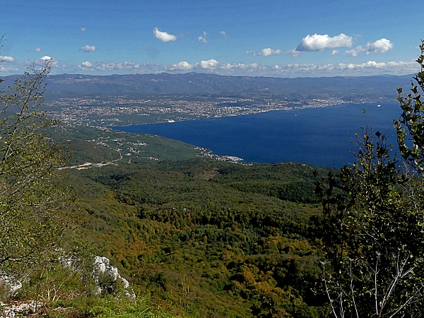 A prime view of Rijeka and the Hvarner Bay ^ 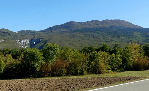 Vojok from the lowest part of the western approach. The transmission tower at the top is vsisible ^ |
 Above that
meeting point, traffic is pretty much a
distant, unpleasant memory. The road is
wide. It stays in the trees and short
sections above 10 percent, like 13 or 14 are
announced with a sign. The grade is
extremely variable. The first view of any
kind (after the ones on the lower approach
options to Veprinac) comes when the road
enters the Ucka Natural Park. Rows of
long Adriatic islands melt in the flat light
against the sun. Two signed mountain bike
routes cross here (route 6 and 7)
Above that
meeting point, traffic is pretty much a
distant, unpleasant memory. The road is
wide. It stays in the trees and short
sections above 10 percent, like 13 or 14 are
announced with a sign. The grade is
extremely variable. The first view of any
kind (after the ones on the lower approach
options to Veprinac) comes when the road
enters the Ucka Natural Park. Rows of
long Adriatic islands melt in the flat light
against the sun. Two signed mountain bike
routes cross here (route 6 and 7)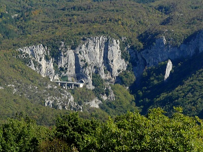 From West. (described
downwards). This decent is about as brutal
as a road as wide and smooth as this can
make it: very variable grade, with very
steep turns. This is a different kind of
road engineering, than practiced in northern
Europe. There are only one or two far views
of the rumpled carpet landscape below.
Finally the road opts to go in a straight
line north, damn the grade whatever it might
be. From below the tower on top of Poklon
does not look so far above as it feels,
having come down from it. It is a mountain,
shaped like house with a slanted roof on
top.
From West. (described
downwards). This decent is about as brutal
as a road as wide and smooth as this can
make it: very variable grade, with very
steep turns. This is a different kind of
road engineering, than practiced in northern
Europe. There are only one or two far views
of the rumpled carpet landscape below.
Finally the road opts to go in a straight
line north, damn the grade whatever it might
be. From below the tower on top of Poklon
does not look so far above as it feels,
having come down from it. It is a mountain,
shaped like house with a slanted roof on
top.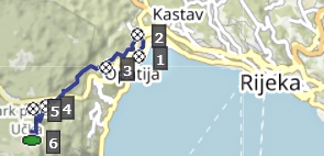 Sidetrip to Vojok(ow) :
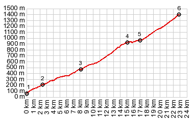
|
|
advertisement |
|
|
advertisement |