| |
| |
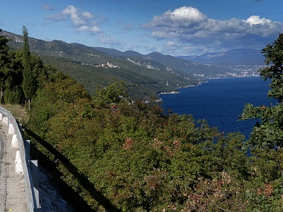
58064 Moscenice - Brsec s(u) D66/E751 follows
Istria's mountainous north-eastern
shoreline very closely. It hugs every bay
and every turn shows something new. It
seems like it would be a great bike ride.
If it only there wasn't this much traffic,
this close to Rijeka. This short section
parallels the main road and leads over a
scenic little summit. I think it is
actually better than anyting parallel
D66/E751 has o offer.
Past the castle there is
virtually no traffic on the road, but the
most substantial part of this small climb is
still ahead. At the top the viewshed changes
somewhat to the north. From South. A relaxed shallow decent leads through small villages, containing an average of about four houses each. A sign states that they have a church and three other things, specified by (to me) undecipherable images. But I only ever say a couple of houses. At the junction with the larger D66, there is one more village, this one a little larger. It clusts around a castle, overlooking the sea: Brsec. Tiny rough stone walkways connect modern doorframes in a small maze of walkway alleys. I wonder what these dwelling look like inside. Are they as old as the stone of the walkways, or as modern and comfortable as the slick modern entrances. I suspect the latter. 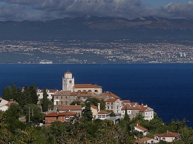
Sidetrip to Ucka Park
Prirode Natural Park entrance: Across
from the castle in Moscenice a sign points
the way to trail to Perun, apparaently an
old abandoned village on top of a rounded
mountain. But actually the "trail" turns out
to be an extremely narrow and steep paved
road, zig zagging up the green hillside. The
views gradually come to include rows of long
islands that are stacked in front of the
Croation coast, like gigantic waves
themselves. The castle too moves more and
more into the domain of the sea. The
pavement ends shortly after a parking lot to
the entrance of the Natural Park. A good
dirt track continues into the high forest
and continues onwards towards various
possible summit points. But I turned around
with my skinny tire touring bike. The short
unpaved section I tried out is entirely in
the forrest and has no views. Slideshow of the
out-and-back paved summit:
Dayride with this point
as highest summit:
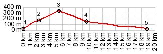
PARTIALLY PAVED / UNPAVED ( < Monte Di Ragogna s(u) | Poklon s(u) > ) 58064 Moscenice - Brsec s(u) : Icici > Lovran > Redveja > Moscenicka Draga > Moscenice <> out and back to a 1-2m beyond end of pavement on paved road to Ucka Park Prirode Nature Park park sign >> Moscenice - Brsec s(u) > Brsec with sightseeing detours > D66 north > Redveja > Lovran > back to starting pint in Icici: 31.8m with 3370ft of climbing 3:42hrs (garmin etrexm30 r5:21.10.13) Notes: short ride after the morning rain stopped sometime before noon 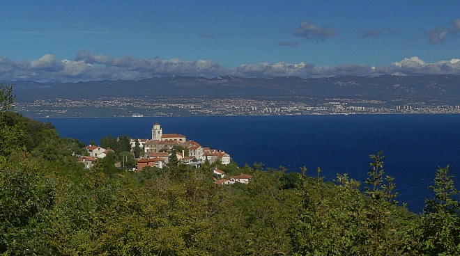 |
 The profile from
here goes back direction north on busier
D66. But this far from Rijeca it is really
not bad at all. Traffic will increase with
each km that you go north. From below the
castle in Moscenice complements the
shoreline, shaped like a wave itself as it
undulates into the stark stalagtite
background composed of the Rijeka high rise
buildings.
The profile from
here goes back direction north on busier
D66. But this far from Rijeca it is really
not bad at all. Traffic will increase with
each km that you go north. From below the
castle in Moscenice complements the
shoreline, shaped like a wave itself as it
undulates into the stark stalagtite
background composed of the Rijeka high rise
buildings.|
|
advertisement |
|
|
advertisement |