| |
| |
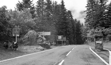
Col de Portillon
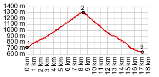
Approaches The summit is in needle forest, and also a
virtual sign forest. The spaces next to the road
are filled with parked cars and RVs, and people
milling about, looking for something of apparent
interest. But there really isn't too much. I too
take the obligatory summit photograph. It is
virtually identical to one that I found on
Panoramio, just that my bike looks a little
different and is not packed as orderly. From East. (described
downwards). The road seems to have no bottom, even
if in reality it doesn't go much lower than where
it started on the other side. At two different
switchbacks I suddenly clinch my brakepads into
screeching position, in order to stop my vehicle
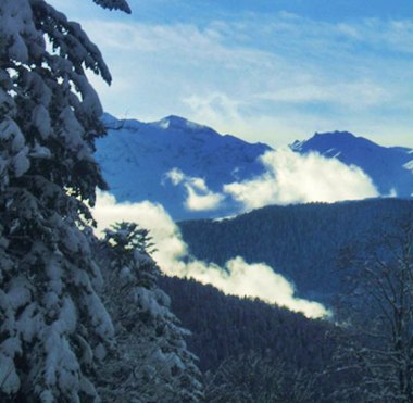
and take pictures of snow capped high Pyrenean
peaks, framed by luxuriant foliage - for me the
most interesting scenes since leaving Vielha. I
would bet it is from the same point as the first
picture on this page. I think in a car the scene
passes to quickly to perceive it, and it would be
too difficult to instantly bring tons of metal to
a stop. At the bottom wait the two adjoining towns
Saint-Mamet and Bagneres-de-Luchon. The latter spa
town features a magnificent, long tourist
promenade, with the main snow capped ridge of the
Pyrenees in the far background - what an elegant
setting. It can also serve as basetown for many
Pyrenean pass rides. On today's ride the town at
the bottom was actually more fascinating than the
pass above. A Day on a Tour with this point as intermediate summit is on page: Col de Peyresroude |
|
|
advertisement |
|
|
advertisement |