| |
| |
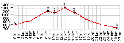
Collado de la Creu de
Perves
This is one of the nicer summits
along the Spanish "Pyrenean Axis" route,
definitely my favorite of the last 3 passes in
this category on this tour. The top is a high
rolling plateau with great views, and two
hilltowns along the way. The second pass on this
route the Collado de Llevata often gets equal
billing, but it is really only a shoulder point.
The road ahead becomes a peaceful climb in the
forest. Not until the first physical tiredness
sets in, do the trees pull back at a few openings
in the forest and the high peaks to the east
become visible, but always with a web of
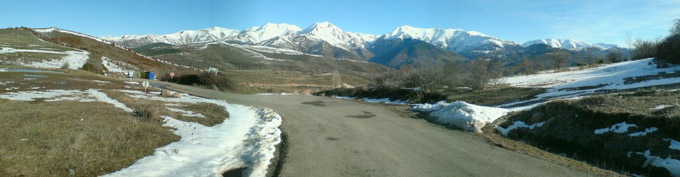
powerlines in the picture. The first signed pass along the way is Port de
Vio. Here the trees are below and a small group of
old houses silhouettes perfectly in front of a
large parade of snowcapped mountains. As the road
enters onto a high rolling plateau this group of
houses stays the scenic focal point for kilometers
of swinging turns in the road. The next pass marked on the map is the Col de
Llevata. All three roads from this intersection
climb mildly away from the pass. It's a mystery to
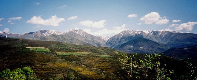
me what this pass divides. But the next marked and signed pass is the unmistakable summit, the Collado de Creu de Perves. The road makes a 90 degree turn to the north and throws open an unobstructed view of a long linear range.
From East. (described
downwards). At the bottom of this endless
spaghetti road is another, from this perspective,
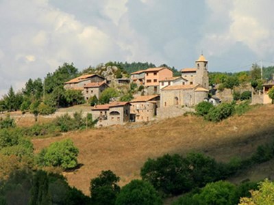
very low hilltown: Perves. Surprisingly this is
only a drop of about 100 meters down to the the
village. I would have guessd that it is quite a
bit more. The roll ahead presents every imaginable
viewing angle onto this old village, and I too
take a whole collection of pictures. Once at the
"city" walls, it turns out to be a tiny place. The
empty streets are walked to their locked ends in
front of abandoned looking buildings and decaying
walls in a matter of minutes. Even the cemetery
has only a few old inhabitants, but again they
have a very scenic spot. At some distance from the
old settlement there are also a few newer houses. Surprisingly - the road just keeps on dropping
into the bottomless forest after that, and now
Perves has a different appearance. No longer the
town at the edge of the tundra, now it's the row
of houses far above on a cliff in the forest. After the last switchbacks the road widens and
straightens considerably and takes on a more
elaborately engineered roadbed. From the wide
highway another small row of houses appears on the
edge, Sarroca de Bellera. The profile ends in
Senterada, a handsome village on the confluence of
Rio de Sarroca and El Flamisell, with the
occasional tourist business nearby, and a chance
to buy more Salami.
A Day on a Tour with this point as highest summit: COMPLETELY PAVED: ( < Collado de Fadas | Pic de l'Orri s(u) > ) Collado de Creu de Perves , Estany de Montcortes : El Pont de Suert > Puerto de Viu de Llevata : Collado Creu de Perves > Perves > Senterada > Estany de Montcortes > Montcortes > Peramea with sightseeing detour > Gerri de la Sal > Sort Notes: gps data and distance data are on stolen computer A Dayride with this point as highest summit: COMPLETELY PAVED: ( < Estany de Montcortes s(u) | Port de Bonaiqua > ) Collado de Creu de Perves , Collado de Montllobar : La Pobla de Segur > Senterada > Collado de Creu de Perves > Viu de Lleveta > N230 south > Puente de Montanana > Collado de Montllobar > Tremp > back to starting point in La Pobla de Segur: |
|
|
advertisement |
|
|
advertisement |