| |
| |
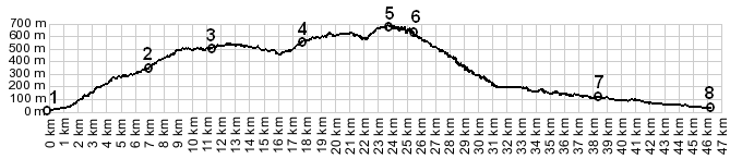
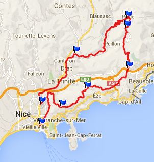
Col de Pacrace
Col de Pacrace is a shoulder
point on one of the favorite popular rides in this
area: Col De La
Madone De Gorbio. But even without climbing
to this higher point, and just crossing this pass,
you traverse one of the most unusual hilltown
settings in this area: the village Pacrace.
From North. (described
downwards). The road goes through a short tunnel,
wich is nontheless important enough that it
sometimes manages to close the entire approach on
this side. As the road approaches Pacrace, it goes
through numerious short tunnels, separated by
viewing perches on the village across the chasm.
The closer the road gets, the more more precarious
and interesting the building situation looks.
Directly across stands a town park up high on a
rock, the way to get up to it, a complete puzzle
for now. Descending a little further beyond Pacrace, a
small turnoff back into the mountains leads up the
Chemin
Strateguiqe des Banquettes s(u). But this
profile continues downhill. Below the turnoff, the
area slowly looks more industrial, when the rock
quarry below takes center stage.
A Dayride with this point as
intermediate summit is on page: Col de l'Orme s(u)
|
|
|
advertisement |
|
|
advertisement |