| |
|
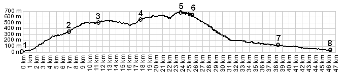
01.(20m,00.0km) START-END SOUTH 1: Nice harbor
02.(327m,06.9km) Col de Quatre Chemins(shp)
03.(507m,11.4km) Col D'Eze(shp)
04.(557m,17.7km) Col de la Guerre(shp)
05.(670m,23.7km) TOP: Col de Pacrace
06.(640m,25.6km) Peille
07.(122m,38.4km) profile turns left from D21 onto D2204
towards Cantaron
08.(40m,46.7km) START-END SOUTH 2: Nice, near railway
station