| |
|
|
|
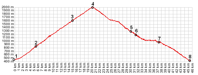
1.(00.0km,449m) START-END SOUTH: la Chambre on river Arc
2.(05.5km,830m) road on right goes to La Pallud, Montaimont and Col de Chaussy
3.(15.0km,1612m) Longchamp and first jct with D76 back down to la Chambre
4.(20.2km,1993m) TOP: Col de la Madeleine
5.(30.1km,1360m) Cellieres Dessus
6.(31.3km,1194m) la Thuile
7.(37.5km,933m) Bonnelval
8.(45.5km,433m) START-END NORTH: la Coulee: jct with N90
|
|