| |
| |
Arthaburo s(u)
This is the second summit on a loop
of famousely steep and scenic summits from
St-Jean-Pied-de-la-Port. The scenery in this part
of the Atlantic Pyrenees is made up of large,
sweeping grassy mountain faces, and I don't know
of any other part of the world that looks like
this. I wonder if there is a similar scenery
anywhere.
The initial supersteep switchbacks have numerous
unsigned turnoffs to farms. But directions are
easy, just follow the Iraty arrows painted on the
road. These markings are left over from the Iraty
endurane race. The narrow path quickly gains a
ridge with equally great views in both directions.
Getting close to the top, the road passes through
two rocks approximating a gate. "20 percent" is
painted on the road for the Iraty endurance
racers. Is that meant to be encouraging or
discouraging ? It is impressivie though. For me,
even more reason to stop at this gate of rocks and
take a picture of the impressive landscape, framed
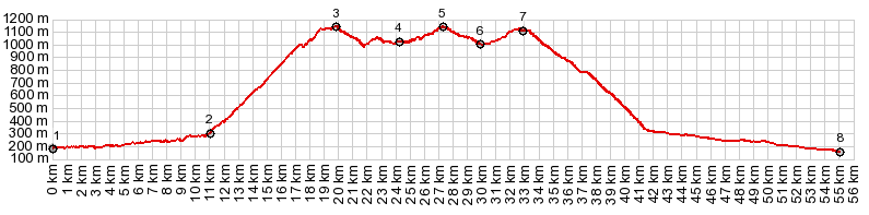
by these rocks. According to the map the road passes a Col de
Arthe at 937 meters before reaching this summit.
There are no signs anywhere indicating either the
pass or the summit described here. The fact that
it was the highest point becomes apparent after a
scenic traverse.
From West. (described
downwards) The next junction is well hidden until
you have practically missed it. As usual an the
word Iraty with an arrow painted on the road urges
everybody to follow the road that stays in France.
The right climbs higher, in order to summit below
the mountain Errotzate (different from the col de
Errotzate, which is lower). But that is hopefully
a different bike ride. Following the Iraty arrow, the road descends to
another scenic herding area, with another road
into Spain that for some reason does not appear in
many popular maps. 1460 meter high Okabe
keeps watch over this junction. Many travelers
coming from the Iraty side stop here, not knowing
that it actually even gets quite a bit better than
this when they proceed. From here the road climbs
again through the forest to Col de Zurzai, before
descending to Chalet de Iraty. Col de Zurzai is
not signed, and there are no comparative views
from there. 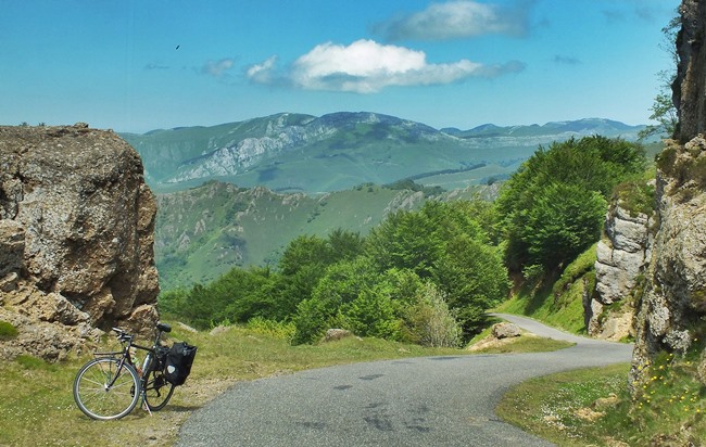 Dayrides with this point as intermediate
summit are on pages:
|
|
|
advertisement |
|
|
advertisement |