< Left Panel   Passes in Italian Alps   Areas   Tables   Maps   All Favorites  
Main Panel:   Main Page   Map+Profile   Picture Page   Alps Map  


Klammjoch


An especially interesting subgroup of passes in the alps are border passes between Austria and Italy. The border generally runs along one of the main ridges of the central alps. These border crossings have a turbulent history spanning two world war. But this region is also a single cultural entity, Tirol, today politically divided into south, north and east. The Klammjoch is fairly good dirt road between South Tyrol and East Tyrol, that some people also cross on road bikes. It has an extensive stretch above treeline.

photo page

01.(00.0km, 856m) START-END EAST: Huben
02.(05.5km, 1088m) Hopfgarten iD
03.(17.0km, 1310m) Schwarzach
04.(21.0km,1387m) St Jakob iD
05.(26.9km, 1569m) stay right, left goes to Staller Sattel
06.(42.0km, 2288m) TOP: Klammjoch
07.(50.7km, 1571m) START-END EAST ALTERNATE: Rain in Faufers /Riva di Tures
08.(61.1km, 882m) turn left in Sand in Taufers / Campo Tures
09.(73.5km, 822m) St Georgen / San Giorgio
10.(75.9km, 834m) START-END EAST: Bruneck / Brunico


A

pproaches

From East. Sankt Jakob is a good starting point for a ride up Klammjoch. But the the very bottom  of this approach is really much lower, and common to Staller Sattel. At the bottom of the Defereggental lies Huben at 819m. Looking for an even lower point to start the day, one could also choose Lienz at 673m. From Sankt Jakob the road to the pass heads east, paralleled on the other side of the river by a partly unpaved bike path. The junction to Klammjoch is signed as Oberhaus. A narrow paved road that can only fit cars in one direction (but is open in two directions) climbs to the (guest house)  Oberhaus Alpengasthof - great care required because of the narrow road and rare, unexpected cars. Peaks above 3000m, still covered in snow in June appear between the trees. Since there is practically no traffic, the background of the rushing mountain stream is the loudest noise.

F

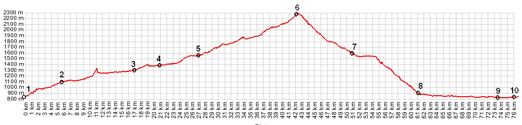
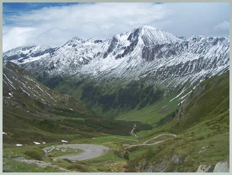
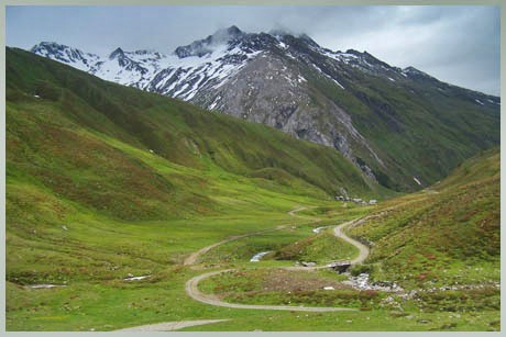
rom Oberhaus the sharp peaks flanking the Klammjoch become visible for the first time as backdrop to the Schwarzachtal (tal=valley). Some up and down through the trees gives way to steady climbing, leading to a large cow herding complex at treeline, the Jagdhausalm. Along the way are several ingenious cow gates, that only consist of a flexible stick of sorts. You can cycle right through it without stopping, but cows are extremely unlikely to cross these barriers. At the Jagdhausalm are two conventional gates as well as stone walls and old picturesque alm buildings. From here the route climbs sharply to what looks like could be a summit. But not so fast, this false summit is a good vantage point onto another old alm (old herding vilage),  but there still is more climbing to be done. Steep V shaped canyons merge into a green, yet treeless valley. Finally a few switchbacks climb to the highest visible point, and then its still another 100ft or so to the unmanned border crossing at the summit. The entire unpaved part of the route is extremely smooth. The upper part is crossed by wooden drainage channels every few hundred feet. They are easy to ride across and provide such good drainage, that even after a day of non stop rain the route can be relatively dry the next day.


From West. 
(also described upwards) A steep paved climb precedes the arrival at Rain. This village lies up on the northern flank of the valley, so climbing up to it provides a grand panorama of the mountains surrounding Grosser Lengstein (3236m) and Dreieckspitze (3031m) to the south. While turning the switchback at the church, you can't help but notice the churchyard, that must be in one of the most beautiful locations for such a thing in the world, at least on a sunny day. All the crosses are stylistically similar to provide a coherent image. The narrow paved road aims straight ahead for a group of sharp peaks. Passing a parking lot, the route turns smooth dirt. Later passing an old alm that looks like a village from the middle ages, the road eventually turns south a bit, and then engages in dozens of switchbacks that work their way up the pass.


Dayride:

Klammjoch x2:  St Jakob iD <> Klammjoch <> 2 miles below Rain-Taufers: 42 miles with 5900ft of climbing in 5:3 hours (VDO MC1.0 m4:9.6.24)
Notes: The Osttirol tourist bureaus also are happy to give away a map with cycling routes, containing amongst others the "around the Riesenferner Group" day ride which goes over Klammjoch and Stallersattel and measures 104km and 2200m climbing, when starting in Sankt Jakob.

The last day with different start and end points on this Extended Tour is on page: Kartitscher Sattel


Klammjoch

Highest Point:
2288m
Eastern Approach:

drop
from Huben (856m)
1432m
42.0km
~50m
from Sankt Jakob iD (1387m)
901m
21.0km
~50m
Western Approach:


from Bruneck (834m)
1454m
33.9km

from St Georgen (822m)
1466m
31.5km

from Rain in Taufers (1571m)
717m
8.7km


advertisement

advertisement