| |
| |
Karerpass
aka pso di Costalunga Karerpass is the main traffic
route between the Bozen (Bolzano) area and the val
di Fassa in the dolomites. It can have quite a bit
of traffic, including buses and trucks. The route
is heavily commercialized. At the beginning of the
western approach are two long tunnels, that are
open to bicycles or can be portaged and cycled
around. Taking this old, partially abandoned road
around the tunnels just may be the most
interesting part of Karerpass.
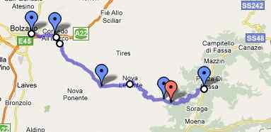
From West. Finding the entrance to the
Eggental from the luxurious biketrail from Bozen
is not exactly easy the first time around. There
are signs, but a few more at critical junctions
would help. Leaving Bozen you can can take the
bike trail running along the river to
Sterzing(Vipeteno) (direction Brenner Pass),
or more easily follow the road out of town and
pick up the bike trail when the road crosses the
river. In the town of Karneid, the bike route
seems to go by the Rathaus (city hall), easily
recognizable by the bluish mural of the "knight of
Karneid", pic3 below. The old road up the Eggental
is currently closed because of a rockslide
(June/09). But with a mountain bike it's an easy
short 1 minute portage over it. The route goes up
the valley to the right of the Rathaus. The old
road snakes through a canyon below a majestic
castle (pic 5), which is much more attractive than
the hole in the mountain the new road goes
through, unless perhaps it's raining cats and
dogs.
If instead you want to take the first 1500m
tunnel (preferable with a loaded touring bike),
you have to turn around at the knight of Karneid
mural and take the bicycle/ pedestrian bridge onto
the other side of the river. If you pass the
object in pic 2 you have also gone in the wrong
direction. The bike path snakes itself around
under the highway over another bridge back to the
east side of the river. The tunnel is now to the
right. Once you pass a red fish on the bike trail
(pic1), which is part of an art gallery next to
the bike path, you again went too far. At this
point it's easiest to hoist the bike over the
barricade onto the highway exit, heading back
towards Bozen and bingo, there's the big rondell
with a sign pointing into the tunnel: "Karerpass".
The well lit tunnel, about 1150m long tunnel joins
back with the old road at the other tunnel end,
only to dive into the next 1500m tunnel within 10
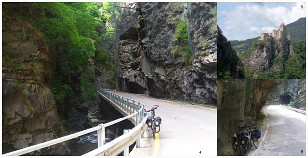
meters. The second tunnel is more easily circumnavigated.
The old road continues on the other side, at this
tiny opening between tunnels, crossing over a
barricade that operates like a train crossing
barricade. The old highway here hangs by the side
of a canyon, that is worth just a look even if you
have to turn around and go back (pics 4 and 6).
But that should not be necessary as a bicycle is
easily hoisted across the barricade on the other
end, meeting the new road where tunnel number two
emerges from the mountain. That old highway with
its hanging rock nets, waterfalls and roughly
hewn, small tunnel of its own may well be the best
part of Karerpass.
Now again in heavy traffic the road makes its way
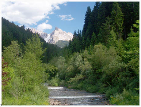
up to Birchabruck, where the first needle like
dolomite peak is seen, direction pso. di Lavace
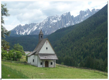
(pic 7). Below Welschnoven, the Rosengarten group
peaks ahead start making regular appearances in
the sky. Pic 8 is taken near Welschnoven. Reality
is not quite as romantic as the picture makes it
appear, as there is a big parking lot and a very
commercial restaurant just outside the frame.
Above Welschnoven the switchbacks get serious, the
grade picks up as the road enters a thick forest.
The last few km below Karerpass are heavily
commercialized, not just with a luxury hotel,
bars, beergardens, but also an equestrian school
and a clothing outlet. No need to worry of dying
from exposure during bad weather. The bars are
happy to have another customer.
From East. (described downwards). The top
of this pass also marks with mind numbing
exactness the end of the German speaking territory
and the beginning of Italian-only speaking
territory. After such a monumental climb, the
descend on this side is surprisingly easy on the
brakepads of a loaded touring bike. The
Rosengarten peaks are now behind, and the really
jagged peaks of the Sella group are partially
obscured by lower mountains. Turning left at the
first of the dolomite tourist towns, heading
towards the Sella group, the road leads uphill
again. Turing right to Moena the downhill
continues.
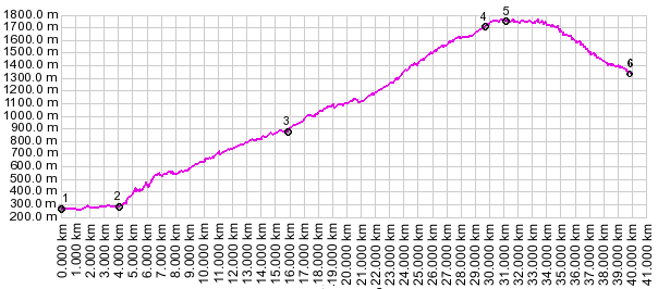
a day on a tour:
(<Penser Joch|Pso di San Pelegrino>) Karerpass: Andrian (a few km north of Bozen) > Bozen > Karerpass > Fontanac (just a few km short of Canazei): 41 miles with 5600ft of climbing in 5:0 hours (VDO MC1.0: m3:9.6.3) Notes: ncludes a fast room search. A Dayride from the end point of this Extended Tour, Fontanac is on page: Sella Joch
|
||||||||||||||||||||||||||||||||||||||||||
 Approaches
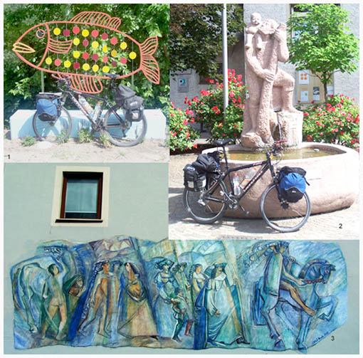
|
|
advertisement |
|
|
advertisement |