Foce a Giovo
I first read about this summit on the Qualdich.de
site. It is directed towards road bike riders, and
they describe this road as not suitable for that.
But of course they had to ride it in order to come
up with that conclusion. Sometimes you just have to
come up with your own conclusions. Still, I have to
agree. Take a mountain bike instead. This summit
happens to be my favorite category of riding. It has
enough rough pavement to keep cars and motors away,
but it's still smooth enough, that you do not have
to jump over anything, and can cover as many miles
as any road bike in a day. If the day is a little
longer, who cares ? - in today's parlance: a
nontechnical mountain bike ride.
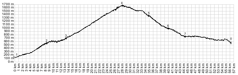 |
1.(148m,00.0km)
START-END WEST: west of Ghivizzano, SP56
turns of SR445
2.(560m,8.7km) route from hilltown Coregia
descends to join with profile
3.(684m,12.8km) another road connects on
the right with mountain locations
4.(1664m,28.0km) TOP Foce a Giovo
5.(1365m,35.0km) dirt road terminates at
gate onto paved road
6.(1000m,39.9km) turnoff to Fiumalbo,
immediately below
7.(900m,42.1km) START-END WEST: Pievpelago
and turnoff to Passo delle Radici on left
8.(580m,56.2km) START-END WEST ALT:
aproximate intermediate low point near
Strettara
|
 Approaches Approaches
From South. Signs in
this area also use the designation "Passo a
Giovo". The most direct way to approach the summit
is from the west side of the Serchio River and
riding up towards Tereglio. But there is not much
there there. Instead there is much more happening
in the upper field of view. Two hilltowns make an
appearance far above during the first few miles
(one of them is Coreglia). And this will also be
the last hilltown view on the entire ride.
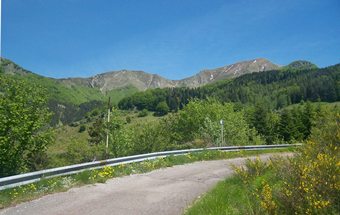
Now the road traverses up the north side of the
valley, periodically adding switchbacks to the
traverses to gain altitude more quickly. An
occasional thick walled private house surrounded
by dense woods passes by, watched over by sheppard
dog, or somebody tending to the yard.
Then the turns start up again. Actually, there
seem to be countless switchbacks on this approach.
But at least the separate sections of switchbacks
can be counted. The second set starts where the
pavement changes to - lets say intermittent -
patches on patches on patches with holes. This
second set tends in a westerly direction and gets
the road no closer to the summit, as the crow
flies. But it does deliver the first views on cut
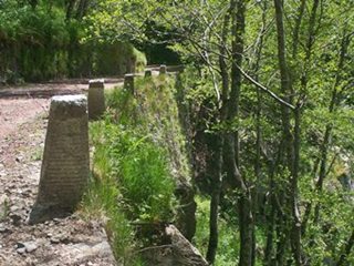
off pieces of pavement in the forest below. While
gaining this ridge, the open forest periodically
disappears completely and gives great views on the
ridge ahead.
The next next set of switchbacks again coincide
with a surface change. First a narrow unpaved road
gives way to a wide, fairly smooth unpaved highway
through thick forest, gaining the ridge with
switchbacks that have the regularity of somebody
doing knee bend exercises.
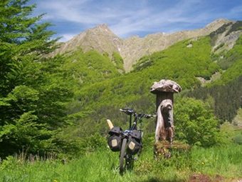
On the last traverse a great view opens up to the
east. A few rugged breadloaf mountains fall off
into vertical cliffs, because these breadloaves
stand on edge. Behind that green ridges recede
into haze. Behind them you think you see the sea,
actually you know it, because a few features
resembling islands are barely discenible. But
mostly you see haze.
The last traverse has one more set of switchbacks
following it. Just a few to finish things off,
above the trees with a great view below and bikers
waiting above.
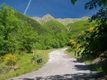
From North. (described
downwards) Actually this side appeared quite a bit
rougher to me surface wise, but the slope is more
gentle. The road remains within 100m of summit
level and contours on an open ridge northwards. To
the north you can make out a town. But these
loosely spaced dwellings have a the appearance of
modern luxury, without the medieval need to huddle
together for safety on top of a hill.
After much rolling the surface improves. However
now there are, what must be hundreds of small half
burried logs across the road, apparently drainage
control. They are not difficult to ride over with
a mountain bike. But the spokes of a trusty old
wheel with any thousands of miles on it may not
hold up to it.
But the road has mercy and pavement is reached
still hundreds of meters above the valley bottom.
At the junction with the paved road, there is no
sign pointing up the unpaved path, just a barrier
and a sign closing the road to cars. Both
directions on this paved saddle go downhill. So
its important to keep a sense of direction.
Descending towards the right finally leads to a
final landing approach in switchbacks, honing in
on the church tower of Fiumalbo, a pleasant
looking town with ski tourism in the winter and
bikers in the summer.
But staying left here the road descends further,
now a wide main road into Pievepelago. Before this
town is reached, staying straight will lead the
way back to the south side of the ridge over Passo
delle Radici or San Pelegrin
in Alpe s(u). That's the way my route went.
But in order to find a lower point on this side I
continued the profile to a low point north of
Montecreto.
Dayride
PARTIALLY PAVED / UNPAVED
Foce a Giovo , San
Pelegrino in Alpe s(u) : Borgo a
Mozzano > unplanned detour to edge of Bagni di
Lucca > Tereglio > Foce a Giovo >
Fiumalbo > Passo delle Radici(shp) > San
Pelegrino in Alpe s(u) > Castelnuovo in
Gagargagna > back to starting point: 69.5miles
with 8697ft of climbing in 7:38hrs (Garmin Etrex30
m4:14.5.25)
Notes: On top I met a group of Italian
mountain bikers who invited me to abuse them
with all the Italian I do not know. Mi dispiace
ma mi Italiano e molto malo. But no it is very
good they answered in English. Still I could see
that periodically I said something very funny,
or maybe it was offensive and ignorant, but
thank you for interpreting it as funny. We
finished the language lessons with a common
picture with the "pane" (bread) in my saddle bag
as central focal point
The last day with different start and end points
is on page: Passo di
Bigorno

|