San Pelegrino in Alpe s(u)
This point is a short distance above Passo di
Radici. But traversing this summit point is a much
different experience. Only from here do you get a
monumental view of the Alpi Apuani (which are not
part of the alps, or geologically speaking of the
Apennin mountains for that matter). From the vantage
point of this summit they actually seem not that
high but still very vertical.
The other outstanding memory I got from crossing
this summit, is the unusually steep direct approach
from Castelnuovo, guaranteed to wear out break pads
on a loaded touring bike downhill, or make you push
uphill. I did the first, and met a brave mother and
daughter team from Boston, trying to get their fully
loaded mechanical donkeys to the town San Pelegrino
before it got dark. The mother was leading the race
by a few hundred meters, as I passed with screeching
brakes in the other direction. Even walking, this is
a substantial workout, just a different kind of
workout. Apparently the names "Passo di Lagadello"
and "Passo de Pradaccio" are also used for the
summit by some.
There is also a Passo San Pelegrino in the alps.
Both are named after the same person who is said to
have died in this village. He is not a saint
according to the catholic church. But some
localities don't seem to be concerned with the
difference.
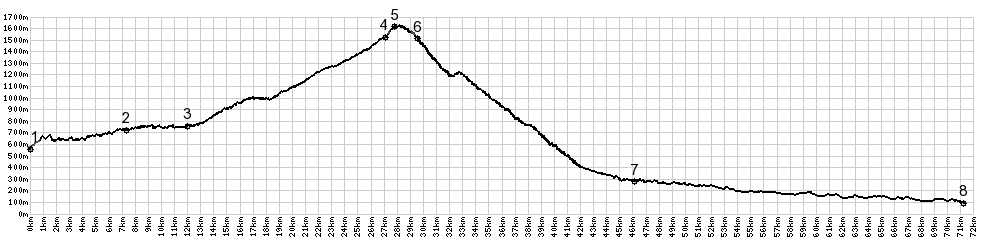 |
1.(550m,00.0km)
START-END EAST ALT: low point on Via
Vaglio below Montecreto
2.(700m,07.4km) Riolunato
3.(790m,12.0km) START-END EAST:
Pievepelago
4.(1510m,28.4km) route turns left on Passo
delle Radici
5.(1600m,27.8km) TOP: San Pelegrino s(u)
6.(1510m,29.6km) San Pelegrino
7.(383m,43.2km) START-END WEST:
Castelnuovo Di Garfagnana; profile turns
left
8.(105m,105.0km) START-END WEST ALT: Borgo
a Mozzano
|
 Approaches Approaches
From East. There are
three different ways to get to the top of Passo
delle Radici. I profiled the one I took, It's a
pleasant curving road, backgrounded by gentle but
ever higher Apennin mountains, still with veins of
snow in late May. At the top of Radici is an
Albergo, a few ski lift artifacts that may still
work, but seem quaint and pleasant in today's
world of industrial quadchair skier mass
transportation.
A narrow straight road climbs noticeable steeper
along a sheer curtain of trees, behind which the
high snowy mountains approach eye level ever more.
Then the road suddenly turns east, and shortly
after that presents a stunning panorama of a
steeply falling landscape, with one more wall
between here and the sea, the Apuani Alps.
From West.
(described downwards) The quickly descending road
quickly reaches a favorite scenic spot. This is a
place, where one can observe otherwise quite
conservative looking people take "selfies", using
the cameras on full sized laptop tablet computers
with the scenery in the background. If it makes you
do that, it has to be unusual. But this spot is
better in early morning light.
Leaving the scenic ridge behind, the road quickly
touches an entry spot into the town. But from the
road there are no points from where this town is
easily visible, at least I did not see any. But at
the summit, tourists congregated on a low ridge
next to the road to the north. My guess is they
were there for a reason. As for my own situation,
time was getting very short to complete the loop
in daylight. So I didn't check it out.
This descent is amazingly steep. Regular sets of
ramps switch off with longer ridgeline traverses.
There are fine views of the Apuani Alps, but they
are better in morning light and look like a paper
cutout in my case. Also, looking back San
Pelegrino is hard to find. The mountain road
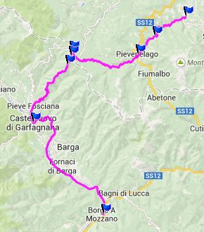
descend ends in Castelnuovo de Garfagagno, which
may make up for having missed the details of San
Pelegrino. The profile continues down valley along
the Serchio River to Borgo in Garfagagna on the
west side of the river. This is a busy road with a
good shoulder, a sort of commute to get home from
the good part of the ride. The upper part of the
road on the east side of the river seems to be
closed to bicycles.
The descend really ends at point 7. I included the
ride down the valley on the west side of the river
Serchio. The other side has less traffic, but is
longer and more hilly.
A dayride with this point as
intermediate summit is on page: Foce a Giovo
History: After dragging a bicycle up or
down these steep switchbacks on the direct
approach, you would never guess that the route is
part of an old historic road, the Via Vandelli,
which was built in the 18th century bettween
Modena and Massa-Carrad on the coast. But builder
Domenico Vandelli chose to make the road very
steep (yes he did!), and the usability suffered
because of that. The biggest crossing of the Via
Vandelli is a hiking route today, Passo Tambura in
the Alpi Apuani mountains.
|